| |
FR58 Klickitat Rd s(u)
Much of this forest route is
paved, but not enough to call it a paved road.
There is no old growth forest along this road,
as in my previous rides through Elliott State
Forest. Instead this is a great way to escape
coastal traffic. But it gets away from the
coastal scenery too. There are several more
direct approaches from the south than the one
in the profile below.
Apparently there is also a
Cummins Creek Road with a bikable trail that
joins FR55 partways up the northern approach.
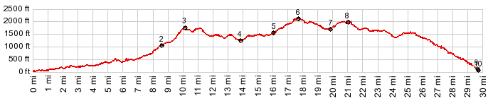
From South. The dirt road
up Big Creek does not pick up in slope until it
crosses the creek and starts a single meander up
the north slope. When it meets FR58 it becomes
an immaculately paved road. But - bummeroni - it
doesn't last. Shortly before the first summit
point on FR58 this becomes a fairly rough gravel
road, for Oregon standards. But after the jct
with FR37 pavement starts up again. Much to my
surprise the road started climbing again too. I
thought the summit was long gone behind me. But
it was still 500ft above - not that it looked
any different, fairly uniform age forest the
whole way. From North. US101 is
little more than a dozen miles away from the
top, but you would never guess this. There is
not as much as the hint of an ocean view from up
here. Just when I was racing downhill for a
clearing ahead, thinking this is the ocean view
at last - it was a clear cut instead, big enough
to contain a midsized city, with enough rotting
lumber left in it to construct one. But at least
there was a far view of some kind from this
point, the first one on the entire ride. The
surface on the downhill alternates many times
between dirt and pavement. The junction with
US101 comes as a complete surprise, so does the
traffic, and during my ride the drop in
temperature into the fog, the change in scenery,
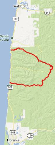
trees, and general everything. Dayride PARTIALLY PAVED / UNPAVED ( < Camp
Creek Rd - BLm25-7-5.1 | Fairview
Mountain Road s(u) > )
|
 Approaches
|
|
advertisement |
|
|
advertisement |