| |
Fairview Mountain Road
s(u)
On the Oregon Coast between
Florence and Yachats, several dirt roads head
west into the mountains from US101. A ride
over Fairview Mountain Road sounded like it
would be the best bet for a great ocean view.
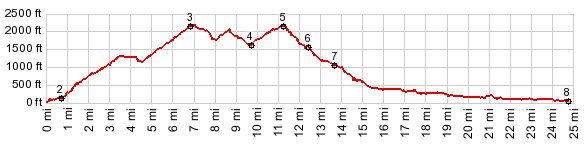
From West. The profile
starts at about sealevel where US101 crosses Big
Creek. The route follows US101 up to the top of
the next hill and then takes the dirt road at
the crest up into the forest. The best moment of
this ride came, where the road climbed out of
the cool coastal layer of haze, and sunlight
refracted through the trees in a fairytale like
spectacle. A good workout leads to the top of
the ridge. The closest thing to an ocean view,
can be had through the trees with a telephoto
lens a long ways below the summit. From South. The road switches over to the north side of the ridge for a short time and then climbs two more summit points. Apparently the last one is the real top. The route becomes paved at the jct with FR58. There are many ways back down from here. The shortest would be Deep Creek Road. But the profile chooses the only completely paved route, staying on FR58 and then descending towards Florence on the Upper North Fork Siuslaw River Road. This is another great isolated forest road with nonexistent traffic and many old moss covered trees to watch out for. Dayride PARTIALLY PAVED / UNPAVED: ( < FR58 Klickitat Rd s(u) | FR17 Cougar Mountain s(u) > ) Fairview Mountain Road s(u) , Fairview Mtn Rd s(u)-2 , addtional out and back: ~1.8 miles up Big Creek Road > down Big Creek Road > US101 north > up Fairview Mountain Road > Fairview Mountain Road s(u) > down Upper North Fork Siuslaw River Road > a few miles around Florence > US101 north > back to starting point: 62.8miles with 4500ft of climbing in 5:46hrs (VDO MC1.0 m3:13.8.6) Notes: The nicest scenery along this loop was admittedly not going over this summit, but along US101 on a very scenic part of the Oregon coast. However, the traffic there in August is horrible, while I saw no cars at all during the climb and the descent of this summit.
-
|
 Approaches
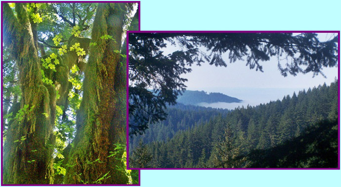
|
|
advertisement |
|
|
advertisement |