| |
Camp Creek Road -
BLM25-7-5.1(sh)
On a previous ride in Elliot
State Forest, a Forest Ranger asked me: "well
- did you go all the way around ?" At that
point, after a long day of riding, I was too
tired to respond with "Around what, and how
long does it take ?" I finally figured out
what he meant when I rode this loop. This
shoulder summit point is one answer to the
question this ranger asked me: It provides one
missing link, to make a loop ride, combining
the unique, wonderful, isolated paved
forest roads in Elliot State Forest with a
long river highway ramble along the Tyee and
Umpqua River - all on paved roads. This is not
the shortest of all such possible routes. That
would go over Little Camp Creek Rd s(u). But
it is not that much longer than that option.
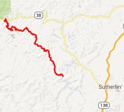
From North. Finding Camp
Creek Road is no problem. You just take look for
a sign on Loon Lake Road (which in turn is
a well signed turnoff from Or38, east of
Reedsport). - And riding up Camp Creek Road is a
pure joy, especially for those who tend to be
memorized by a wild brook flowing along behind
what seems like impenetrable jungle. There is
more on that climb on the BLM23-8-28:
Elliot State Forest(sh) page. When you get to the top the road
presents a puzzle. Four paved roads meet here.
Examining the totality of evidence of signs,
where they are pointing, how they are oriented,
standing or lying destroyed next to the road,
one can piece together a few facts about this
intersection. The road crossing at right angles
from the arrival point seems to be numbered
23-8-28. The one going downhill in the opposite
direction seems to be numbered 25.7-5.1. Does
that help any ? I didn't think so! After riding
all the roads - not in one day of course - I now
know, that the one descending to the Tyee River
is the opposite one, going down and numbered
25.7-5.1, Actually I found out when I got to the
top (see the notes below the dayride). The
crossing road leads to two summit points: BLM23-8-28
Elliot State Fores(sh) to the left and the
higher BLM23-8-28 Elliot State Fores s(u) to the
right. De Lorme gazeteer map only show
BLM25.7.5.1, BLM25-8-28 to the left and Camp
Creek Road From South. (described
downwards). There is even a momentary far view
of the landscape, immediately after the top. But
it really is not much to look at, just a
haphazard clear cut patter in a muddle of green
hills. For me, the close views of the
amazing jungle like forest are more interesting.
And this descend has its share of dead trees
reflecting in moss surrounded pools. It is quite
a large descend for being so close to the coast.
As you approach the bottom, the clear cut areas
start to dominate the landscape again. The
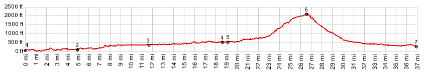
profile ends at the jct with Tyee Road at a
bridge across the river. 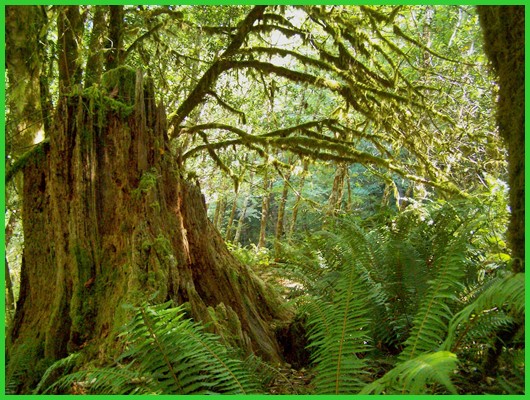 Dayride COMPLETELY PAVED: ( < BLM25-8-28:
Elliot State Forest(sh) | FR58
Klickitat Rd s(u) > ) But he knew the way he came up,
and I knew the way I came up, which was the
way he wanted to go down and vice versa. We
had an extended conversation about truck
campers, his one year trip he is on in one of
them, rainshadows in Washington State,
computer wireless services, water reserves in
truck campers,climate differences in the north
west, how to classify water falls and a host
of other topics, only limited by the lack of
time. This would become a late day for me
anyway. But you meet the best people in
the most out of the way places. "First I
thought I would probably meet a logger
up here, who would send me in the wrong
direction - just out of spite" he said.
The number of cars I encountered on Elliot
State Forest paved roads in 4 days of riding
would not require all my fingers (luckily I
have all of them), which makes this meeting
extra - extraordinary.
-
|
 Approaches
|
|
advertisement |
|
|
advertisement |