| |
SFR7000 Scholfield Ridge
Road s(u)
This is a gravel road in
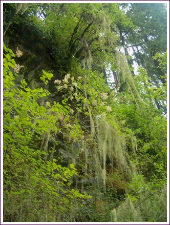
Elliot State Forest. For me the most
interesting part of this ride was the old
growth forest on the lower approach of Umpcoos
Ridge Road. All the pictures were taken there.
But you can use that road also to get to other
summit points.
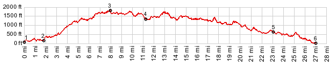
I haven't really found any maps that map and label all of these roads correctly. In this case the MapQuest rendering has far fewer errors than the google maps version. However the profile was made with the google road traces, so there are inaccuracies in the profile.
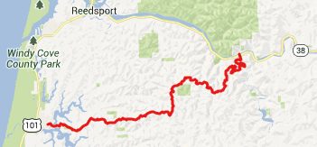
From South. Just as it was
a pleasure to turn off busy US101 along the
Oregon Coast onto Or38 up the Umpqua River, it
is again a pleasure to turn off still busy OR38
onto Mill Creek Road, heading for Loon Lake. But
the next turnoff is even better. For me it was
the best part of the ride. The first non-gated
turnoff to the right leads up SFR7500, also
labeled Umpcoos Ridge Road on maps (labeled
FR7000 on google maps, but correctly labeled on
map quest). The first several miles lead through
moss covered old growth forest, climbing steeply
up the ridge to the north. At the first major
intersection, the profile turns left onto
SFR7000, but still called Umpcoos Ridge Rd.
Surprise - the magic is over - replaced by a
clear cut. The road traverses over it. But this
way you also get the first far view. It was
impossible to tell this during the ride, but
according to the map this seems to be the
highest point on the ride.
From North. (described
downwards) So far all intersections were labeled
with SFR numbers, that actually did correspond
to the ones on my map. The next one was the
first discrepancy, and after that the signs
along the road disappeared for a while all
together. Umpcoos road stays right and heads
down hill on SFR5100, or SFR5000 according to my
map. The profile stays left and climbs a little
higher on SFR2000, Scholfield Ridge. Parts of this side seem to be more
heavily graveled. Rolling along the profile does
not stay on Scholfield Ridge for long, but
descends on SFR2000, then 4000, a series of many
short descends that are just a tiny bit longer
and higher than the preceding ascent. Somewhere
to the west, between those trees must be a
pacific ocean, and you can imagine the boundary
between the white clouds and the white sea, but
I never actually saw it. The dirt road terminates on paved
North Lake Road, and signs direct to take a left
turn into Lakeside. Dayrides. (< Grey Butte s(u)
| Buck Creek/
Lindy Creek Rd s(u) > ) -
|
 Approaches
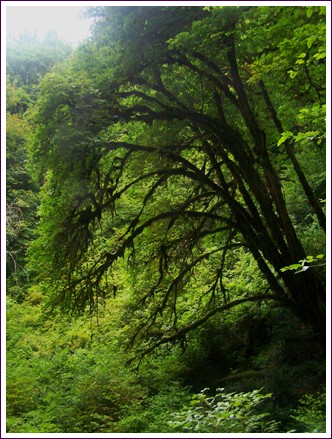
|
|
advertisement |
|
|
advertisement |