| |
| |
Grey Butte s(u)
One of the great, paved cycling
climbs of northern California is a ride up Everitt
Memorial Hwy to a shoulder on Mount Shasta. With a
mountain bike and a little bit of walking this can
be made into a two way summit
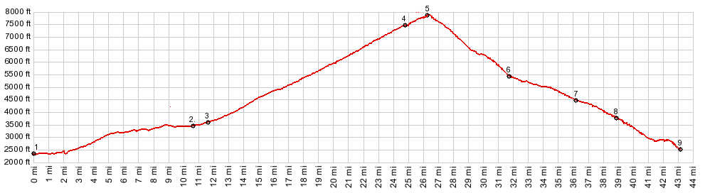
The subject of the slide show on
this page is of the Everitt Memorial Hwy paved
approach up to the Panther Meadows trailhead, and
also a few pictures of the section between points
6 and 7 on Skipark Rd. The subject of the slide
show on the external page (link on the left side)
is the out and back ride of the summit section of
the Everitt Hwy (above the trailhead) and the
short summit section on the trail and dirt road.
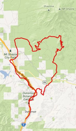
From West. Roads west of downtown Mount
Shasta City funnel into a paved road that seems as
wide as a football field, when it passes the local
high school. It starts to climb right away, road
signs pointing to Mount Shasta. There are
individual mileage markers with the current
elevation along the road. But some of them seem to
be missing, unless exhaustion got the better of
me. The first views are impressive, a massive bulk of
a mountain behind brush forest. Then the road
enters stretches of forest. The hills below
dissolve in haze, that it's hard to tell where sky
ends and hills start. The mountain comes into
sight again at the first major trailhead at Bunny
Flats. A little higher the walk-in campground at
Panther Meadows is marked by a hand painted sign,
that reminds me of the artistic style of San
Francisco posters from the 60s. It was painted by
the local naturalist, residing at the meadow, told
me the campground host. From here a short hiking trail leads to the top
of Grey Butte. There are no signs forbidding
bicycles, but riding across the first part of this
trail across a mountain meadow would be heavily
frowned upon, understandably so. But you
should not carry an urn of a loved one in your
handle bar bag and dispose of the ashes.
"Disposing or scattering ashes on Panther Meadows
is strictly forbidden, and the ashes will be
removed" a sign reads. It sounds to me like
removing scattered ashes would be a difficult
task. How do you remove something that has been
carried away by the wind already ? I carried my bike for the first couple hundred
yards, and took care to only step on the stepping
stones on the trail.. Another trail off the main
road also connects to the meadows trail, a little
higher. 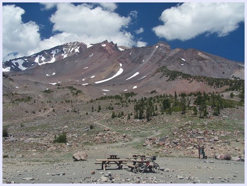 resting up on the highest spot of the Everitt Memorial Highway After that the trail climbs a low ridge that
connects Grey Butte with the mass of Mount Shasta,
and conditions are too rocky to ride. Then the
trail crosses the ridge, showing off the first
great views of the eminence above, turns
right and traverses along the ridge to
quickly reach the microwave towers on Grey Butte.
Riding that second section is possible, if you
want to take your life into your hands. On top
stood not only microwave towers, but also a pickup
truck full of people fixing the former. I didn't
expect to have a conversation about cell phones on
this ride on top of this mountain. But I did. From East. (described downwards) This
side of the mountain makes a fascinating contrast
to the "memorial highway". Patches have been clear
cut, others have been "ski aread", and who knows
what else. The steep switchbacks alternate between
being very rocky or sandy, but all of it is
ridable in a downward direction. But just rolling
back down the asphalt would definitely have been
more enjoyable. But actually pavement is not that
far away. The first part of the descent ends under
chair lifts, passing between snow guns. Next comes
the victory lap around the ocean of asphalt that
makes up the ski parking lot. "thank you" the sign
directed at leaving skiers, reads as you exit. Now
a well paved road descends into forest. There is a
locked gate on this road, something to remember
during the new found rush of speed on
pavement (especially if it's getting dark). There are several ways to complete this descent.
Returning to Mount Shasta City would best be
accomplished, turning right on FR31 Old Mc Cloud
HIghway(sh). Or you could let gravity carry you
down Ski Park Road to Snowmay Hill
s(u), where one can descend further on busy
Ca89 back to Mount Shasta City, or in the other
direction Mc Cloud. This is what the profile does.
By the way, going straight down another dirt road
direction Dunsmuire or Castella is probably the
scenically most attractive option. That options is
described as part of the Snowman's Hill
s(u) page. Sidetrip to the end of Everitt
Memorial Highway This is really almost to short to
call it a side trip. It is only about 200ft more
of climbing. And it wouldn't make sense to skip
this scenic collection of picnic tables at the
bottom of a mountain throne like this. It is
possible to camp up here, including on the parking
lot of what was once a ski area. - The fact that
this was once a ski area parking lot explains the
large amounts of now crumbling asphalt in those
last switchbacks. Dayride PARTIALLY PAVED / UNPAVED / HIKING TRAIL ( < FR19
Deer Mountain Road s(u) | SFR2000
Scholfield Ridge s(u) > )
|
 Approaches
|
|
advertisement |
|
|
advertisement |