| |
| |
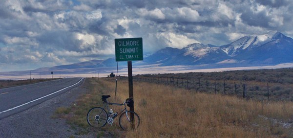
Gilmore Summit
For all practical intend and
purposes this road is flat. There is nothing
approaching a large radius curve, that might cause
a motorized vehicle to slow below the 65mph speed
limit. And still, this is a summit, shown on Idaho
state maps, signed at the top, complete with
elevation and name. It also manages to gain over
3000 on its north side and close to 2000 feet on
the south side. It just takes a whole lot of miles
to do it. Still, the character of ride over
Gilmore Summit is that of a ride along the
mountains. A friend characterized a perhaps
similar ride (the old DBTC century along the Front
Range north of Denver) like this: "The scene just
doesn't change. Every once in a while you're
tempted to drop something off the bike, like a
water bottle, just to make sure you're still
moving."
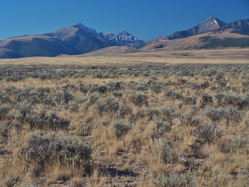
 But it doesn't have to be like that. Maybe the night before an early fall storm dropped a dusting of snow on the peaks, while drenching the valleys in rain. The clouds still hang heavy over the Lemhi Range during the start of the ride. As the sun slowly pulls off the covers later during the day, it presents an ever changing spectacle of clouds, reflecting light, changing shadows, a ray of sun turning selected parts of the mountains into a moving display. The light changes constantly. At times it silouets the massive shapes into a paper cut out - just for half a minute until the next act starts with the next ray of light, that is beginning to pierce the cloud cover. This used to be hard to capture on film. But with digital photography zooming in on distant details has become much easier. In scenery like this these pictures capture representations, that are often so small and distant, you have to look hard to actually be aware of them. Dropping the water bottle won't help with that. Another thing that makes this summit outstanding becomes clear when you travel the 100 miles from the north through the Bitterroot Range over Lost Trail Pass or Chief Joseph Pass or Gibbons Pass to here. All those passes are at slightly lower altitude than Gilmore Summit. But they never reach above timber and you can't distinguish the scenery from all the trees. It is one unending forest up there, while down here but roughly at the same altitude it's one great desertscape and the presence of trees causes placenames to reflect this unusual fact.
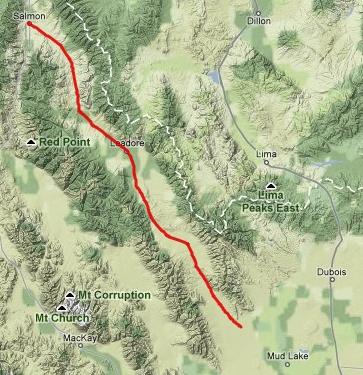
From North. Leaving the settlement of
Leadore, the road does begin to climb, but just
noticeably. The road runs closer to the Beaverhead
Range on the East Side. The distant rounded shapes
look more like giant anthills from this angle. The
Lemhi Range to the west is a distant rugged wall.
After a short distance you can actually make out
the mountains, lining the valley on the opposite
side of the summit. But it is difficult to tell
that these distant mountains, will not be passed
until after crossing the still 18 mile distant
summit. As the road slowly climbs further it seems
to head right for the Lemhi Range, at one point
barreling straight towards Timber Creek Peak
(10553ft) and Sheephorn Peak. Getting very close
to the summit are two dirt road turnoffs to
Gilmore, an old mining settlement. The last few
miles are actually something of a more than
noticeable climb. The top has large name and
elevation signs. The view down the south side is
even larger in scale than the north side. From South. (described downwards). The
summit is also a water divide between Eighteen
Mile Creek to the south and Divide Creek to the
north. A dirt road leads to a wilderness study
area along Divide Creek. Our main road continues
to draw closer to the Lemhi Range as it descends
from the summit, but this does not subtract from
their imposing appearance. The place name "Lone
Pine" is signed as being 42 miles distant from the
outskirts of Leadore on the northern approach. But
this "place" does not show up on most maps. When
my odometer turned to 41 I noticed a distant grove
of pine trees silhouetted against snow covered
peaks on the right side of the road, the first
pine trees since many miles before Leadore. Could
"Lone Pine" be just lone pines ? All that was
missing was an official name sign pointing to
them. But as it turned out, people lived at this
"Lone Pine". Don't know how many, but shouldn't be
more than a dozen. It even has a little store
selling gas, chips and soda, and a sign saying
"cafe", meaning "get your burgers here". It goes
without saying that there are no other human
structures or services between Leadore and Lone
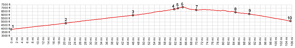
Pine. Tours Dayrides. An out and back ride: Leadore <> Gilmore Summit <> Lone Pine measured 86 miles with 2500ft of climbing in 5:4 hours with a little help from the wind (Vetta 100A r2: 10.9.10)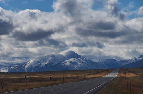 History Fur Trade: A member of David Thompsons Columbia expedition reportetly discovered this valley in 1818 while on a trapping expedition with Michael Bourdon. To other trappers the valley was known as Cote's Defile. Mining: It is doubtful that this would be a named summit if it weren't for miners in the 1880s, who worked Horseshoe Gulch for lead and silver near the summit. It definitely would not carry the name Gilmour, and that even though the miners had no intention of naming it that. in 1902 residents of Horseshoe Gulch filed for a charter to officially name the town in honor of Jack T Gilmer. When the written answer came back from Washington the name was misspelled as Gilmore. The path of least resistance was to just accept the unintentional new name. Soon richer deposits were found in other parts of the valley and a smelter started operation. Ore and boullion were transported down the south side of the pass to the 67 mile distant railhead in Dubois, Idaho. For a short time steam engines were used to pull four ore carts each. When they wore out they were not replaced. Railroads: A branch railroad named the
Gilmore and Pittsburgh railroad was constructed
over Bannock Pass
from Montana in 1910, then up the north side of
Gilmore summit in order to transport mining ore.
The railroad stopped operation in 1927, due to a
power plant explosion. Before mining operation
could resume the great depression hit in 1929. The
railroad resumed limited operation till 1940 when
the metal rails were finally sold as scrap metal.
|
 Approaches
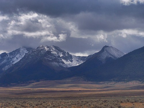
|
|
advertisement |
|
|
advertisement |