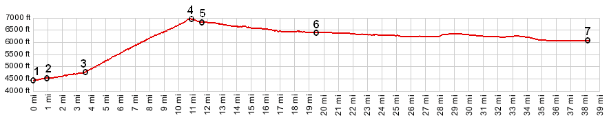
| |
| |
Gibbons Pass
 The combined
Beaverhead/Bitterroot ranges reach north from
Idaho's Snake River Plain, almost to the Canadian
border near Lake Pend Oreille. Over this distance
the character of the range changes several times.
South of Salmon a steep rocky skyline forms an
imposing backdrop of peaks from the Lemhi Valley.
By the time these mountains reach Gibbons Pass to
the north, they are a big bulk of green, densely
forested hills. The continental divide, which has
faithfully followed the ridge line of these
mountains, takes its leave from the Bitterroots
and heads east along the more rugged Anaconda
Range. A little further north, the Bitterroot
Range also shows off another rugged side, the
rocky escarpment west of Hamiliton. The combined
Beaverhead/Bitterroot ranges reach north from
Idaho's Snake River Plain, almost to the Canadian
border near Lake Pend Oreille. Over this distance
the character of the range changes several times.
South of Salmon a steep rocky skyline forms an
imposing backdrop of peaks from the Lemhi Valley.
By the time these mountains reach Gibbons Pass to
the north, they are a big bulk of green, densely
forested hills. The continental divide, which has
faithfully followed the ridge line of these
mountains, takes its leave from the Bitterroots
and heads east along the more rugged Anaconda
Range. A little further north, the Bitterroot
Range also shows off another rugged side, the
rocky escarpment west of Hamiliton. Gibbons Pass is also one of the
most historic passes in Montana. It's not just the
Lewis and Clarke story, which seems like to be
documented with tablets at every turn of the road.
The pursuit of the Nez Perce Indians by Captain
Gibbons also took its first tragic turn here.
Furthermore the pass was the main route of
traffic, prior to the construction of US93.
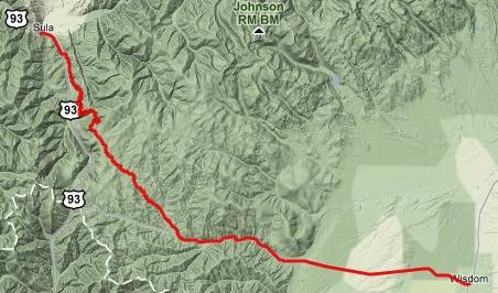
Approaches From North. When US93 passes through the
collection of houses, known as Connor. It has no
rumble strips - no shoulder either. The road winds
along the west Fork of the Bitterroot River,
accompanied by a wide collection of humanoid
habitat. The structures range from roadside
residences to businesses like the the naughty
Moose Restaurant, and log cabin vendors to small
saw mills. The residences too span the gamut from
old shacks to large mansions with equally large
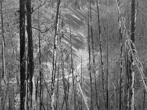
for sale signs. The background is a picture of
devastation left from the last forest fire. It
accompanies the rider almost to the top of Gibbons
Pass. But we are still on the lower, busy paved
section. Sula is a gas station /bar, reminding the
passerby that the next gas station south is 43
miles away, implying that he should not mind
paying the extra cost that this business charges.
Leaving Sula several neglected tablets tell the
story of Lewis and Clarke's meeting with Indians,
here at the junction of West Fork and the
beginning of the northern ascent to Lost Trail
Pass.
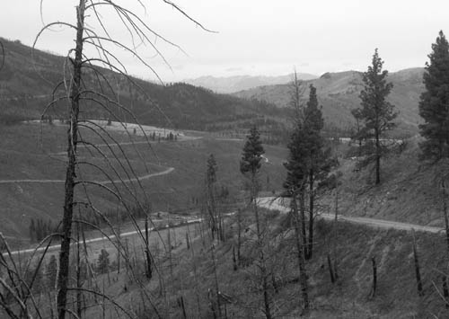
After about a mile the dirt road to Gibbons Pass
turns off to the left. It is well signed. It
parallels paved US93 for a few miles, then
traverses up the slope to the left. As it gains
altitude it enters what is left of the woods, a
black and white matchstick forest. Open views are
opener now. The rocky ridgeline of the Trapper's
Peak portion of the Bitterroot Range starts to
appear as background to the stark shape of naked
trees. The various meanders that have been climbed
already make up the middleground of the view. The
road cut for Gibbons Pass can be seen ahead, past
the next long detour into an indentation into the
hills. Once this section of road is reached, it
seems much higher than it did from below, partly
due to the effort required to get here, and also
because the Bitterroot Crest behind the Hamilton
area is now more completely visible. Finally the road enters green trees, more than
just trees - a thick healthy forest, the views
disappear. At the shallow top, which seems like an
average spot in an average forest, a whole
collection of historical signs mentioning Lewis
and Clarke, Chief Joseph and Capt. Gibbons line
the pass.
From South. (described
downwards). This side has a completely different
character, not only because the area devastated by
fire, ends here. There is also very little
evidence that you are on top of a ridge. An ever
so slightly slanted surface leads through open
meadows and wet lands. This must have been a
sought after camping area during Indian trail
days. Granted, there is a slight downhill, the
bike does roll a bit faster.
History Lewis and Clarke (<Lolo Pass|Big Hole
Pass>): After having spent a relatively
comfortable winter at the mouth of the Columbia
river, the group split up on the return trip.
Using their newly discovered geographic knowledge,
Lewis and nine soldiers headed directly east,
while Clarke together with Sacajawea and the rest
of the group recrossed Gibbons Pass in order to
retrieve the cached canoes. Rather than descending
into the Lemhi Valley, this time they descended
into what is shown as the eastern approach above,
and then continued over Big Hole Pass.
There are two Big Hole Passes in this area. This
is not the rough continental divide crossing, but
the today paved road west of Dillon. Chief Joseph and the Nez Perce
Indians (<Lolo
Pass|Big Hole>):
After the Nez Perce alluded a trap set for
them at Lolo Pass, the band of Indians moved south
through the Bitterroot Valley over Gibbons Pass.
They descended over the eastern approach, of what
has recently been named as Chief Joseph Pass (and
is also the eastern approach of Gibbons Pass shown
above), into the Big Hole Valley and found
Gibbons and his troops ready to accept their
surrender. Chief Joseph preferred to fight. In the
ensuing two day battle Gibbons lost a howitzer,
2000 rounds of ammunition and 68 men wounded or
killed. Joseph and his band escaped south over Big
Hole Pass. |