| |
| |
Big Hole Pass
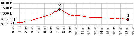
One look at the elevation profile
shows that this is not a major climb. It is
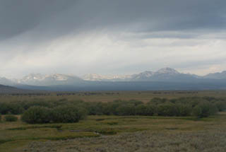
however a great bike ride through the wide open
southern Montana cattle range kingdom. There is so
little traffic here, there aren't even any rumble
strips, which makes this an especially enjoyable
pass for Montana, where often shoulders cannot be
used by cyclists due to wide rumble strips,
running directly down the center of the shoulder.
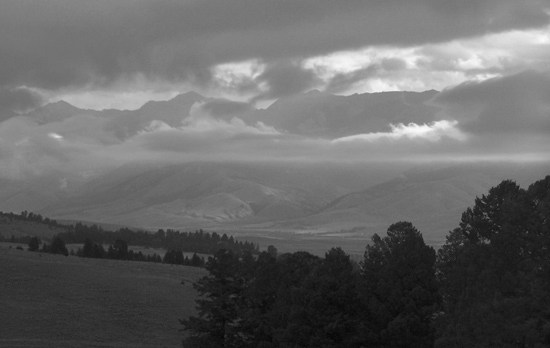
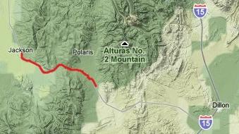
From East. The description starts at the
junction of the designated Pioneer Mountain
scenic byway with Mo278. The road designated as
"especially scenic" branches off right to ramble
through meadows of the Pioneer Mountains, while
the road to Big Hole Pass leaves the Pioneer
Mountains over something resembling a small roller
coaster. The entire pass approach consists of one
single large radius 50 degree turn, and in the
process of climbing up it, views of the Pioneer
Range gradually become better than anything on the
designated Pioneer Mountain scenic byway. But by
far the best views are a small distance above the
pass itself. A chainup area for trucks above the bottom
reinforces the not quite so small size of this
seemingly small bump in the road. The stretch
between the chainup parking lot and the top
appears like a simple short straight ramp, not
much longer or steeper than what New York drivers
might use to get onto the George Washington
Bridge, yet in reality there is potentially enough
climatic difference involved to change the
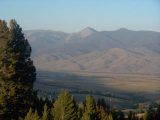
seasons. From the top a dirt road runs south along
the Big Hole Divide into National Forest land with
a few great campsites with outstanding views.
There is also a disproportionately huge parking
lot with a 2 foot explanatory sign, pointing out
where Capt. Clarke (from Lewis and Clarke) camped
on his return trip.
Dayride An out and back ride, starting in the middle:
Carrol Hill on the Big Hole Divide > down west
side of Big Hole Pass <> Jackson <>
turn around point about 4 miles beyond Jackson at
signpost 50m, at the turnout praising the fishing,
beauty and more of Big Hole Valley along with the
friendliness of its inhabitants <> back over
Big Hole Pass and down the East side <> turn
around point at jct: Mt278 - road to Polaris >
back to starting point: 55 miles with 3000ft of
climbing in 4:1hours (VDO MC1.0 m3:10.8.27) History Lewis and Clarke (<Gibbons Pass) Big
Hole Pass was on the return trip of the Lewis and
Clarke expedition, which at this point was really
only the Clarke expedition. During the first leg
of the expedition, the way west, instead of
crossing the continental divide when they first
approached it, Lewis and Clarke had made a 400
mile detour to the south in order to look for
horses, that would help them on the unavoidable
portage. Consequently they had cached their boats
far to the south. Clarke went to retrieve them
while Lewis was heading directly east. The return trip proceeded much faster and the
party reports to have covered two hundred miles in
four days while crossing over Big Hole Pass. But
the group did make note of the Hot Springs and
made notes on cooking their food in them. They
soon raised their canoes from Horse Prarie Creek
and quickly proceeded back east. But technically
speaking this was not the last pass they crossed.
Clark with Sacajawea and nine others escorted
forty nine horses back up the Gallatin Valley to
the Yellowstone River. It is conjecture wich pass
they crossed, most likely Bozeman Pass, but
possibly also Bridger Pass or Flathead Pass. Chief Joseph and the Nez Perce (<Gibbons Pass|Big Sheep
Creek Divide>) After their encounter with
Gibbons and the US army in the Big Hole Valley,
Chief Joseph and his Nez Perce Indians continued
over Big Hole Pass and then the old Bannack -
Medicine Lodge Pass road. Today's maps refer to
this route as Big Sheep Creek Divide followed by
Bannack Pass.
|
 Approaches