| |
| |
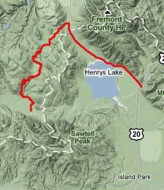
Lone Tree Pass
Lone Tree Pass is an obscure
range land pass in the Henry's Lake - Red Rock
Pass area. Nontheless it has unequalled views of
the sharp north facing escarpment of the
Centennial Range. The pass is marked on Deerlodge
National Forest maps. The north side is fairly
easy to reach. Route finding on the south into the
Centenial Valley is difficult and requires quite a
bit of walking.
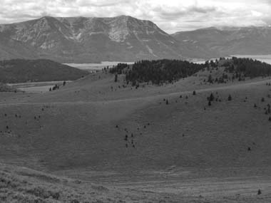
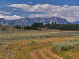
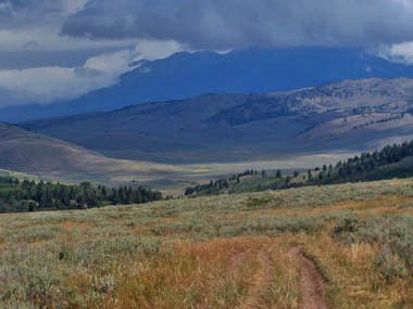
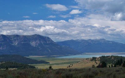
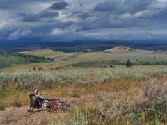
From North. The profile starts near Henry's Lake, goes up the minute ascent to Raynolds Pass, crosses it and then turns left onto a forest road, signed Antelope Basin. A short sharp ascent leads across several rubber drainage barriers. From the top the view of the Madison Range is already better. The road descends slightly through range and forest country. A left at a junction leads to a few steeply climbing curves, eventually delivering the rider to a cow trough of sorts. There are several faint tracks leaving from here, and to me personally the spot looked suspiciously like another cow trough, from which dead end tracks radiate outward like spokes, creating endless confusion. However - in this case - taking the left faint path across a cattle gate leads to an uphill, turning left after a short distance, and then right through a small section of forest where the trail is much better defined. The double track trail climbs into a wide meadow, getting closer to a wide gentle range land saddle. Across yet another gate a junction offers a shorter return directly to the top of Red Rock Pass by staying left. To the right a lone tree can be seen standing above a trail crossing. That's the destination. There are great views of the Centennial Range from Sawtell Peak over the Red Rock lakes to the Lima Reservoir.
From South. (described downwards). This
downward portion required the most energy,
paradoxically. A traverse heads west crosses
several points, that are at about the same height
as the pass. The road becomes better defined and
enters a aspen forest, sloping downhill. Where the
road crosses onto state land, the most used trail
turns right. To the left is a closed road that is
barely a trail anymore, and straight ahead is a
trail/road of questionable integrity. That's the
one I took. However after a while it curves back
uphill into the mountains. I opted for a single
track trail heading down into the Centennial
Valley. This lead to another junction with a trail
down into a ravine. Unfortunately it becomes a
fence line trail that detours west. Opting for
cross country travel on open range land I headed
for dirt road Mo509 running the length of
Centennial Valley, The road is clearly visible.
Unfortunately this involved also crossing a swampy
section of Red Rock Creek. The forest map shows a
different option along trails that parallel Red
Rock Creek on the north side.
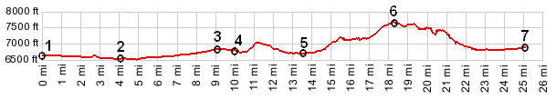
Dayride PARTIALLY PAVED / UNPAVED / OR NO TRAILjct Targhee Peak FR - US20 > Raynolds Pass > up forest road marked Antelope Basin > Lone Tree Pass > down various trails to Mo509 > At this point it was raining profusely, so that I accepted a ride in the back of horse trailer together with two mild mannered horses over Red Rock Pass to Henry's Lake Rd > ride back to starting point. This ride on a Friday the 13th in August measured 43 miles with 2900ft of climbing in 4:3hours (m3:10.8.13). back to Montana's passes and summits by bicycle |
 Approaches
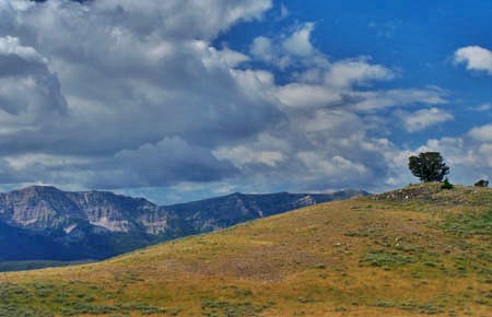

|
|
advertisement |
|
|
advertisement |