| |
| |
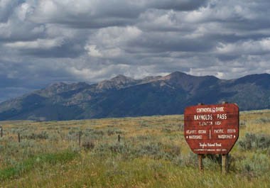
Raynold's Pass
 In New Mexico roads often
cross the Continental Divide without much fanfare,
often without barely the hint of a climb, and
motorists take no notice of the quickly passing
green sign saying "continental divide".
Historically too, continental divide crossings
this far south were of little importance. Not so
in Montana. Raynold's Pass was first named "Low
Pass", a good simple description, and was heralded
as one of the great pass discoveries. As it turned
out the low crossing turned out not to be that
important, but the name stuck. Traffic on this
road is much lighter than on nearby Targhee Pass,
which makes Montana's rumble strips still
dangerous, but not as dangerous. In New Mexico roads often
cross the Continental Divide without much fanfare,
often without barely the hint of a climb, and
motorists take no notice of the quickly passing
green sign saying "continental divide".
Historically too, continental divide crossings
this far south were of little importance. Not so
in Montana. Raynold's Pass was first named "Low
Pass", a good simple description, and was heralded
as one of the great pass discoveries. As it turned
out the low crossing turned out not to be that
important, but the name stuck. Traffic on this
road is much lighter than on nearby Targhee Pass,
which makes Montana's rumble strips still
dangerous, but not as dangerous.
From North (Atlantic). From the jct of
US20 with US89, US89 can be seen aiming straight
for a low gap ahead. The road could be called
straight as an arrow, if it wasn't for its
numerous, undulating ups and downs in its 9 miles
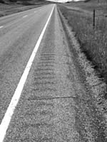
to the summit. The road has a wide shoulder but it
is rumble stripped down the middle so that riding
on the shoulder is impossible. Cyclists are forced
to ride in traffic, making this side needlessly
dangerous. However traffic is light so conditions
are much better than the Montana side of nearby Targhee Pass. The
top has a large sign and a nice view of the range
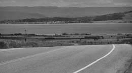
to the east. From South. (Pacific) described
downwards. The shoulder remains, but the dangerous
and annoying rumble strip disappears as soon as
you cross into Idaho at the top. The quality of
the ride improves tremendously. Henry's Lake
shimmers above the asphalt crest of the top and it
is only 200 feet down to it
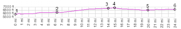
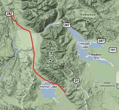
Dayrides. jct: Targhee Trail forest road - US20 > Targhee Pass >
West Yellowstone > US287 nort and west >
Hebgen Dam > Raynolds Pass > back to
starting point (including between 5 and 10 miles
of slow detours near West Yellowstone): 75 miles
with 2500ft of climbing in 5:3 hours. History The Fur Trade. The route of Lewis and
Clarke served as a reference route for subsequent
explorers, who were motivated by trapping beaver
for their fur. It seems silly today, but beaver
covered hats were all the rage in European cities
at the time. One of the principal players in the
Rocky Mountain fur trade was the Spaniard Manuel
Lisa. A partner and employee of his was John
Colter, legendary rediscoverer of Yellowstone
Park. In 1810 after his Yellowstone escapades,
Colter and thirty American and French trappers
built a fort at Three Forks. Blackfeet killed
several of them and convinced Colter that life was
too short, to go on gambling it away like this,
and he returned east to enter his bean growing
period. But Manuel Lisa already had a new partner.
Andrew Henry decided to take a look at the Three
Forks situation still in the same year, and was
promptly chased away by Blackfeet. His flight from
arrows and muskets lead him in a new direction, up
the Madison River. In the process he crossed
today's Raynolds Pass to the lake that would be
named after him. At the time the lake was filled
with islets surrounded by beflowered sections,
which Bannack Indians used to burry relatives. The
Henry group descended all the way to near today's
St Anthony, Idaho. There they built a fort and
wintered. But the fort had a brief existence, and
most of the them crossed back over Raynold's Pass
(or possibly Targhee
Pass) and returned down the Yellowstone. The
exception were three hunters in the group Hoback,
Robinson and Reznor who went on to cross Teton Pass. From now
on trappers spoke of crossing "North Pass" and
meant either Raynolds or nearby Targhee Pass.
Exloration by the Military and Surveyors. By 1860 Jim Bridger, the famous mountain man, had seen the fur trade come and go. That year he was hired again for a mountain expedition later in his life, this time to take a military expedition into the Rocky Mountains. The war department had assigned Captain Raynolds a whole list of impossible exploratory tasks. The captain was happy to condense the assignment into what he called an exploration of the Yellowstone. They left from Fort Casper on the North Platte. Jim Bridger and the captain had different ideas of how to proceed into the mountains. The route they finally ended up taking crossed Union Pass, which Raynolds named, then onwards to Jackson Hole, then over Teton Pass to Pierre's Hole. A week's time of traveling north along the mountains brought them to the same low spot above the beflowered lake. "I named it Low Pass and deem it to be one of the most remarkable features of the Rocky Mountains" Raynolds wrote in his journal. They continued over the pass to Three Forks and returned to Fort Benton. The captain was proud of his "exploration of the Yellowstone", even if he never laid eyes on it. In 1871 tourism was just beginning in nearby Yellowstone National Park. This was the year when the epic exploration of the Hayden Survey mapped the region carefully. They called the pass Madison Pass. Montana Gold Rush (<Teton Pass|Mt287 summit(u)
Enis - Virginia City>): Good times in
Bannack only lasted a year. Then the gold was
played out. But new finds were being made in
Virginia City. Raynolds Pass was on an access
route that lead from Jackson Hole over Teton Pass,
Raynolds Pass to Enis and onwards to Virginia
City. back to Montana's passes and summits by bicycle |
 Approaches