| |
| |
MT 287 summit(u) Ennis -
Virginia City
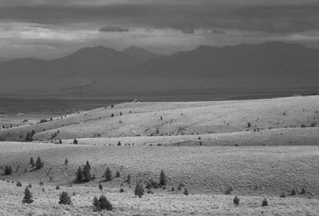
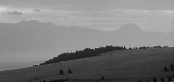
Generally speaking you have to
climb a high point to get a far, unobstructed view
of the landscape. The Madison Valley is not a
place like that, thanks to the virtual absence of
tree or bush that could possibly obscure the
magnificent, ragged skyline and the sweeping,
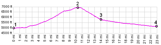
almost neon green valley floor. The summit on
Mt287 between Ennis and Virginia City is 1800 ft
higher than the valley floor and arguably offers a
still better view than the valley. This is not a
huge pass, but it is bigger than many named passes
in Montana, and it is located on an old historic
gold rush road. So it is surprising that this
crossing over the Greenhorn Range was never
designated with a historic name.
Approaches From East. Ennis is the only major
settlement in the Madison Valley. It offers all
services, if you want to go fishing, go on a bird
hunt, reload your guns or eat an overprized meal.
As for bicycle parts this is not the place. The
traffic leaving town can be a bit intimidating in
the beginning. There is no shoulder of any kind,
and in Montana this can actually be a good thing.
The reason is that virtually all shoulders are
rumble stripped, though the agregiousness in
destroying the shoulder as a usable bike path
varies. However, here there is no question if the
shoulder is ridable or not - there is no shoulder
- and consequently motorists cannot get aggravated
if you don't ride on it.
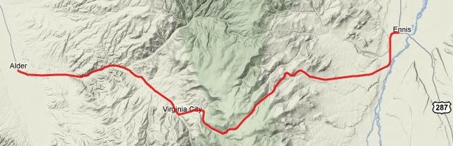
From West. (also described upwards). One
could argue that the very bottom of this road is
at Twin Bridges. However there really is very
little climbing until you pass through the first
Montana gold rush town of Alder. A whole series of
old west towns give this approach a special
interest, some of it authentic, and some of it
resurrected as the Old Vigilante Gift Shop or the
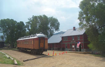
Outlaw Cafe. Nevada City has an old train depot
and vintage railroad coaches parked in front. On
the east side of town an ornamented old mansion
exudes an atmosphere of pleasing decay as it rots
away between old car wrecks and no trespassing
signs. Virginia City is slightly more tourist
commercialized, but beneath all is real history,
and it still feels more authentic than Ennis
during fly fishing festival. The climb starts in
earnest east of Virginia City. A climbing lane
starts here and disappears again quickly, as a
steep slope leads through sage brush hills to the
summit. There is also no shoulder, but traffic is
really not that bad for this to become a problem. Tours Dayrides. An out and back ride from Sheridan <> Virginia City <> Mt287 summit(u) <> Ennis measured 68 miles with 4000ft of climbing in 5:2 hours on a windy, cool, late August day (Vetta 100A r2:10.8.20).
History Montana Gold Rush (<Raynolds Pass|)
Even though this little summit is rarely mentioned
when it comes to the history of Montana's gold
rush, it was traversed by many miners. The Old
Virginia City Road runs runs south of the modern
highway on the east side of the pass. In 1863/64
when gold was found here, some of the gold seekers
came from Jackson Hole, traversing Teton Pass, Raynolds Pass,
descending the Madison to Enis, and then turned
into the hills over this unnamed summit to reach
Alder Creek. Virginia City became territorial
capitol from 1865 to 75. The Ruby river was called the Passamari by the
Shoshoni. The name "Stinking Water" was used by a
Denver editor who wrote about the Montana Gold
Rush, worrying it would act as a draw on Denver's
population. The name stuck with the miners. Later
it was mistakenly renamed the Ruby River, running
through Ruby Valley, even though the rocks found
were actually garnets. |