| |
| |
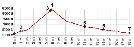
Teton Pass Yellowstone Park lies on high
volcanic plateau. Rides over the paved, named
passes in and around the park have hardly any
climbing at all. There is one exception. The
Teton Range to the south is breached by just one
paved pass. It takes advantage of a low gap, so
that views limited. There is a nice bike trail
following an old abandoned road on the east
side.
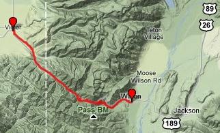
From West. The small
town of Victor has a big surprise. Big enough for
one food market, the town is also big enough for
clearly painted, wide bicycle lanes. Three cheers
for Victor. But actually - the best way to get out
of town is to head west for one or two blocks and
take the "Old Teton Highway" mixed use trail,
paralleling the new highway. The mixed use sign
indicates everything from roller skating, skiing,
bicycling to automobiles. Watching out for all of
these transportation modes, I only encountered two
automobiles on the entire length. The road/trail merges with the new
road at the entrance to the mountains. - What a
shock, more traffic than the Long Island
Expressway during rush hour. As the road crosses
into Wyoming the width of the shoulder increases
to a comfortable width, and the road begins to
climb more steeply. At one point you see the pass
ahead, where a transmission line crosses a hardly
impressive gap in the forested ridge. It did not
seem as high to me from that vantage point, as it
did once I arrived there. The road becomes quite
steep getting nearer the top and winds to the
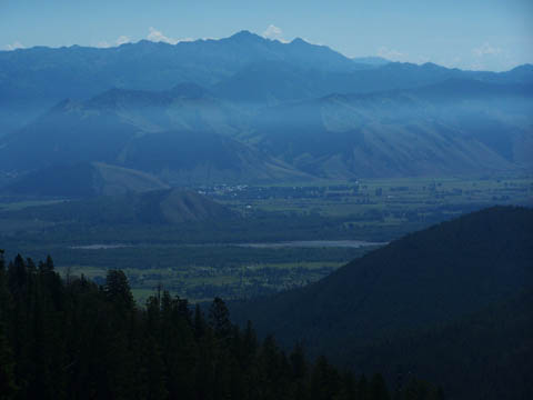
summit with a few wide curves. There are no views to speak of on
this approach - until you get to the top, from
where one can wonder at Jackson lying in its
picturesque hole. At the location where you
discover this sight signage informs in forced
local Gunsmoke lingo: "Howdy stranger, yonder is
Jackson - last of the old west". From East. (also described
upwards). From Jackson the road has a wide
shoulder that makes the rush hour national park
traffic bearable. The profile starts where the
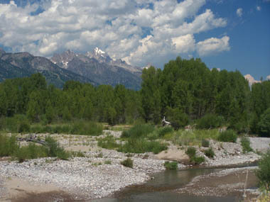
road crosses the Snake River. Adjacent is the
Emily's Pond conservation area, also the only view
of the Teton peaks along the entire route - the
only but also a very nice view (picture in second
row below). In the small town of Wilson a bike
trail on the left side of the road starts. At a
junction the bike route continues up Trail Gulch
Road. The first time I rode this, it seemed that
it was easy to miss this turnoff. I had the
impression, the bike route is so secret you might
suspect that local resident Dick Cheney is in
charge of bicycling in Jackson. But now signs seem
to be everywhere and the surface of the trail
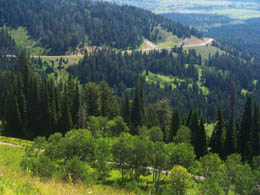
itself is quite a bit smoother too. Paved bike route used to be a little
of an overstatement, What was an old, abandoned,
deteriorating road bed, partially taken over
by wild flowers in now an impeccably surfaced,
fairly wide trail (Sept/23). After a mile on Trail
Gulch Road, the road reaches a sign that finally
shows a map of the trail together with a whole
network of mountain biking trails, crisscrossing
the hard topped bike path and new highway. A sign
forbids the use of E-bikes. I think that
controversy has just begun. The path climbs
steeply, but looking ahead the modern highway
already seems hundreds of feet above. It seems
hardly possible. The highway did this with the
help of a wide swerve to the north. The bike path
catches up in altitude to the new highway with a
few closely spaced switchbacks, and finally
closely parallels the new highway for the last
half mile or so.
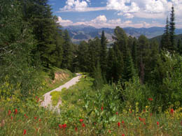
Picture locations: top left:
bike trail and Jackson Hole; top right: modern
road, bike trail in foreground; bottom left: bike
trail again; bottom right: Snake River crossing at
eastern start of profile; bottom: summit view
looking east during late afternoon light. History The Fur Trade. Lewis and Clarke had crossed the enormous east west extend of the Louisiana purchase in 1806 via Lemhi Pass. While Lewis and Clarke did not return to the new western frontier, for other participants of the expedition, this was only the beginning. Lewis wrote to president Jefferson about the potential for trading furs from the Rocky Mountains, and lobbied for a trading post on the Columbia River. Jefferson encouraged John Jacob Astor, a German born fur capitalist, who had dreams of controlling the fur trade from Russia via China to America. But he was not the only one, interested in profiting from the fur trade. There was also the Canadian Fur Company headed by Simon Frazier, and the independent Spaniard Manuel Lisa. God help the beaver from the onslaught caused by the whims of fashion. Beaver of Montana and Wyoming were on their way to becoming nothing but fur lined hats. Employed by Manuel Lisa was also a member of the Lewis and Clarke expedition - John Colter. Later he would become famous for his legendary solitary exploits in what is now Yellowstone Park. In the winter of 1807 Manuel Lisa and 40 of his employees established an impermanent settlement for the winter on the east side of Bozeman Pass, near the confluence of the Bighorn River with the Yellowstone: Fort Lisa. This location, east of where Billings is now, was familiar from experience with the Lewis and Clarke expedition. One way to get beaver fur was to
trade for them. All it took was beads, shawls and
other trinkets, and Indians would part with their
furs. John Colter was willing to venture alone to
the Crow Indians and try his luck. This winter
walk of John Colter has become a legend of wild
west history, and how much truth it contains has
been debated in many books. Later John Colter
would tell stories of petrified birds singing
petrified songs and other tall tales. The kernel
of truth turned out to be as strange as the
fiction that surrounded it: the geysers of
Yellowstone Park. What is known about Colter's journey is that he traveled by foot, carried 30 pounds of supplies and started his long walk by crossing Prior's Gap south of Billings. From there he reached present day Cody within striking distance of Yellowstone Park. From there on speculations of his route differ, but one biography by Burton Harris has Colter crossing Togwotee Pass into Yellowstone and then Teton Pass twice back and forth from Jackson to the west side. In any case, Colter unraveled the geography of the area and that included the Jackson Hole area. Subsequent legends have him stripped naked by Blackfoot Indians, escaping assured death by alluding them and diving into a beaver lodge and then somehow making it back to Fort Lisa. Two years later in 1810 more bad experiences with Indian torture sent Colter back to Missouri. Manuel Lisa had a new partner, Andrew Henry, who again headed south from the old Lewis and Clarke route to build Fort Henry near present Anthony, Idaho. From there they continued over the barely perceptible present day Raynolds Pass ascended Teton River to the top of Teton Pass. Fort Henry only lasted a year but it helped to pass on the knowledge of Teton Pass. A Hunt did eventually reach the Pacific, but the trip could not be described as a success by any stretch of the imagination. They got lost, food ran out, illnesses, water ran low, others drowned. Six months earlier the Canadian David Thompson had laid claim on the area for England. As far the see faring Astorians, they had succeeded in building Fort Astoria beneath a large American flag, but business was poor, and the ship was no more. It had been seized by Indians and the captain was murdered. Subsequently the boat was blown up with the Indians still aboard. All the two branches of the Astor expedition could do was unite and try to make their way back home to the east and tell Astor the the bad news. The return trip lead them over Teton Pass again, but not before Indians and other perceived dangers had caused them a 26 day / 260 mile detour over Wyoming ranges to the south (among them Salt River Pass). After crossing Teton Pass for a second time the detours continued. On this last detour they stumbled over a discovery that would have more impact on westward expansion than anything else the Astorians had done. They found South Pass. This route which can really not a mountain pass in the conventional sense, but a shallow path around the mountains. From a historical perspective it was the one discovery that made easy east west movement of goods and people possible. Exploration by Military and Surveyors. In 1860 Captain Raynolds was assigned a whole set of exploratory tasks, which he happily condensed into what he called "the exploration of the Yellowstone (River)". With Jim Bridger as a guide they left Fort Casper and ended up taking Sheridan Pass and Union Pass to Jackson Hole. From there they crossed Teton Pass to Pierre's Hole. A week's worth of travel north along the Teton Range brought them to the crossing that the captain is still remembered for Raynold's Pass. Montana Gold Rush (<Badger Pass|Raynolds Pass>):
As gold in the Bannack City / Grasshopper Creek
area of Montana was depleted a new fever hit the
mining crowd. The latest riches were located on
Alder Creek and Virginia City sprang to life.
Teton Pass served as a miner's road from from
Jackson Hole and Green River, continuing over
Raynolds Pass and Enis.
Dayrides with this point as
highest summit COMPLETELY PAVED: Teton Pass x2: near jct
FR391 - Wy33 on FR391 <> bikepath next to
Wy33 east <> Wy33 east <> Teton Pass
[highway on way down, bikepath on way up] <>
Wilson <> Jackson with a few slow extra
sightseeing miles << <> separate out
and bach from jct FR391 -Wy33 <> Wilson
<< turnaround point at outskirts of town: 55
miles with 4200ft of climbing in 4:4hours
(r2:10.8.4). ( < Togwotee Pass | Antelope Pass
> ) same summit points: near jct FR391 - Wy33 on FR391 <> bikepath next to Wy33 east <> Wy33 east <> Teton Pass [bikepath both ways] <> WIlson <> Fish Creek Rd north << with turnaound point at end of pavement <> separate out and back from Wilson <> Fall Creek Rd south << with turnaround point at jct with Mosquito Creek Rd: 51.1miles with 5210ft of climbing in 5:07hrs : garmin etrex32x r4:23.09.19) |
 Approaches
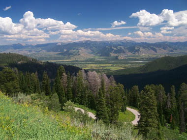
 long
with Andrew Henry were three hunters Hoback,
Robinson and Reznor. These three ended up passing
on the knowledge of Teton Pass to the competition.
This is the turn of events that lead to the
surprising events. In 1811 John Jacob Astor put
together two expeditions, the socalled Astorians,
to reach the Pacific coast and establish a fur
trading post. One was to go by sea, the other by
land. The one by land was lead by Wilson Price
Hunt of Trenton New Jersey, whose main
qualification for the job was having tended a
store in Saint Louis. Their intention was to
follow the Lewis and Clarke route. One day, near
present Niobrara, Nebraska - who comes floating
down the Missouri - but our three hunters from the
Andrew Henry Trip: Hoback, Robinson and Reznor.
The latter experts warned the Stuart novices about
the fierce Blackfeet and impending Indian attacks.
And so Stuart persuaded the three hunters to
postpone their homeward trip down the Missouri in
order to guide the competing Astorians as far as
Fort Henry. For the three trappers this also meant
abandoning the boats in favor of horse travel.
Their route would lead them across the Bighorn
Range over Powder River Pass. The direct route
familiar to the three hunters would have lead them
over Togwotee Pass towards Fort Henry. But two
Indian guides told them about a detour over Union
Pass south along the Wind River Range. The Indians
guides argued this route was better because of
better game hunting for provisions. This lead them
eventually to approach Teton Pass from the south
east at Jackson Hole. On September 5, 1811 Hunt
described Teton Pass as an easy well beaten trail;
snow whitened the summit and northerly slopes at
the heights. At Fort Henry Hoback, Robinson and
Reznor left the Hunt expedition, and so did the
Indian guides. As it turned out, this would not be
the last time that Astorians crossed Teton Pass.
long
with Andrew Henry were three hunters Hoback,
Robinson and Reznor. These three ended up passing
on the knowledge of Teton Pass to the competition.
This is the turn of events that lead to the
surprising events. In 1811 John Jacob Astor put
together two expeditions, the socalled Astorians,
to reach the Pacific coast and establish a fur
trading post. One was to go by sea, the other by
land. The one by land was lead by Wilson Price
Hunt of Trenton New Jersey, whose main
qualification for the job was having tended a
store in Saint Louis. Their intention was to
follow the Lewis and Clarke route. One day, near
present Niobrara, Nebraska - who comes floating
down the Missouri - but our three hunters from the
Andrew Henry Trip: Hoback, Robinson and Reznor.
The latter experts warned the Stuart novices about
the fierce Blackfeet and impending Indian attacks.
And so Stuart persuaded the three hunters to
postpone their homeward trip down the Missouri in
order to guide the competing Astorians as far as
Fort Henry. For the three trappers this also meant
abandoning the boats in favor of horse travel.
Their route would lead them across the Bighorn
Range over Powder River Pass. The direct route
familiar to the three hunters would have lead them
over Togwotee Pass towards Fort Henry. But two
Indian guides told them about a detour over Union
Pass south along the Wind River Range. The Indians
guides argued this route was better because of
better game hunting for provisions. This lead them
eventually to approach Teton Pass from the south
east at Jackson Hole. On September 5, 1811 Hunt
described Teton Pass as an easy well beaten trail;
snow whitened the summit and northerly slopes at
the heights. At Fort Henry Hoback, Robinson and
Reznor left the Hunt expedition, and so did the
Indian guides. As it turned out, this would not be
the last time that Astorians crossed Teton Pass.|
|
advertisement |
|
|
advertisement |