| |
| advertisement |
| -------- |
| advertisement |
|
FR437 summit(u)
Forest Road 437,
leaving the valley near Talpa (Taos
area) is probably best known to mountain
bikers for providing access to high sections
of the South Boundary Trail. But the climb
on this smooth dirt road is an excellent
workout in its own right. FR437 provides a
way of cycling to 10000 feet in a quick,
efficient manner. In spite of this
relatively high altitude, the entire route
exhibits a forested foothills character.
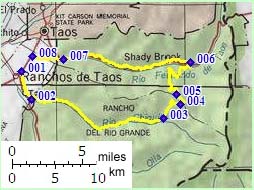
From South. The dirt road leading up Rio Chiquito Canyon is exceptionally smooth and leads up a lush wooded canyon, following a gurgling stream. After a long warm up, the FR437 leaves the stream and climbs steeply up a side canyon. There are no views on top, just a pleasant, rounded, forested hill with various cowgrates and junctions, including FR438 to Osha Pass. Access to the western part of the Southern Boundary Trail, heading for Quintana Pass, is hidden away from the road. From North. Heading up from Valle
Escondido, FR437 is rockier on this side. It
also carries a little more traffic.
Dayrides. A circular ride from Taos to Talpa, traversing FR437 over the summit, returning to Taos via the lower part of the Palo Flechado Pass road measured 46 miles with 3930 feet of climbing in 4.4 hours, using a Cateye 100A cycle computer setup. back
to New Mexico's Summits and Passes by
Bicycle |
 Approaches