| |
| |
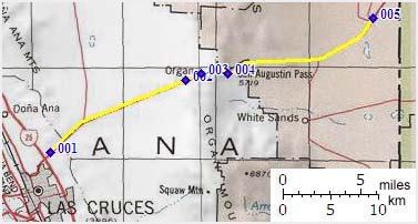
San Agustin Pass
 San
Agustin Pass is the I70 route passing between the
Organ Mountains and the San Pedro Mountains east
of Las Cruces. On an extended tour it could be
part of a long section without services between
Alamogordo and Las Cruces, traversing a dessert
that is largely off limits due its use as a
missile range, air force base and military
reservation. An exception to this military land
use monopoly is the White Sands National Monument
with campground about 30 miles east of the
starting point of the eastern approach. The pass
makes an interesting out and back ride from Las
Cruces in great December weather. Many maps use
the English designation "San Augustin Pass"
instead of the Spanish spelling. San
Agustin Pass is the I70 route passing between the
Organ Mountains and the San Pedro Mountains east
of Las Cruces. On an extended tour it could be
part of a long section without services between
Alamogordo and Las Cruces, traversing a dessert
that is largely off limits due its use as a
missile range, air force base and military
reservation. An exception to this military land
use monopoly is the White Sands National Monument
with campground about 30 miles east of the
starting point of the eastern approach. The pass
makes an interesting out and back ride from Las
Cruces in great December weather. Many maps use
the English designation "San Augustin Pass"
instead of the Spanish spelling.
Approaches From West. Leaving Las Cruces, a one
way frontage road parallels I70 east of its
junction with I25. One way shoulders reserved for
bicycles are part of these frontage roads. These
shoulders are also a signed bicycle route. The
boulevards crossing the frontage road lead into
new developments, most of which are dead end
circles. An initial small climb becomes a barely
discernible grade as the the Organ Mountains
pierce the sky behind a sea of newly built houses.
This may well be the most distinctive view along
the entire route. The frontage roads together with
the bike lanes continue to just before the town of
Organ. Baylor Canyon is the the closest road to
the Organ Mountains, providing trail access to
serveral trail points. Continuing up San Agustin
Pass, the cyclist continues on the shoulder of I70
through the trailers and business ruins of Organ.
Houses continue to within a couple of hundred
yards of the crest. The summit leads through a
large rock cut and contains a sign with name and
elevation. Just beyond the summit a parking lot on
this side contains a display of an old small
missile. 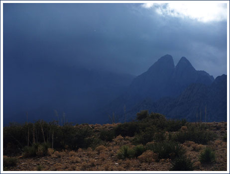 From East. Looking up I70 from the
turnoff to the White Sands Small Missile Range,
the approach to the pass looks deceptively low
and shallow. It's just a single large sweep up an
alluvial fan, leaving the rugged needles of the
Organ Mountains to the left. The cyclist has a
spacious shoulder, where three different layers of
pavement peter out one after another towards the
right, which also makes the shoulder a little
difficult for skinny tires. Both sides of the road
are fenced and labeled with do not enter warnings
in English and Spanish. The road is often closed
for an hour or two due to activity and the White
Sands Missile Range. By the time you pass the
turnoff to the Missile Range headquarters it
becomes clear that this is a real climb,
especially when the pass funnels a strong headwind
in your face. Shortly before the pass a turnoff to
the Aguirre Springs BLM area provides access to
another strip of land in the Organ Mountains,
before the Fort Bliss military reservation blocks
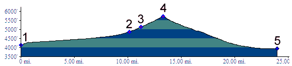
access to its southern peaks. Tours Dayrides. (paved): An out and back ride from Radium Springs to Las Cruces, joining the profile at the junction with Del Rey Boulevard, continuing over the pass to the White Sands missile range turnoff measured 81 miles with 4000ft of climbing in 6:3hours using a Vetta cycle computer (r2:7.12.16).(MTB+paved+portage): A loop ride with an
additional, optional approach started in Radium
Springs and continued > Las Cruces > Baylor Pass >
Aguire Springs BLM area > San Agustin Pass >
back to Las Cruces and Radium Springs, and
measured 70 miles with 3100ft of climbing in 6:0
hours, on a sunny day with perfect temperatures
between Christmas and New Year. Ride statistics
were measured with a VDO MC1.0 cycle computer and
do not include the portage which probably amounted
to about 500ft of climbing in an hour
(m3:07.12.30) back to
New Mexico's Summits and Passes by Bicycle |
|
|
advertisement |
|
|
advertisement |