| |
| |
Austin Summit
From a distance (like a vantage
point below Pete's
Summit) the Toiyabe Range look like a huge
hull of a boat upside down. It seems like they
would be the biggest obstacle that US50 has to
overcome on its way west, before crossing the
Carson Range to Lake Tahoe. And even if it's not
the highest point on that stretch of road (that
would be Robinson
Pass), if you add both approach heights
together, by this measure - this climb is the
biggest.
But statistics aside, the road still picks the gentlest crossing it can find and real impressions of the Toiyabe Range are limited.
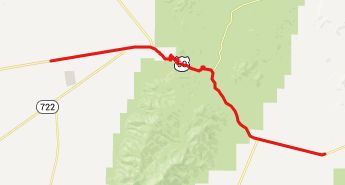
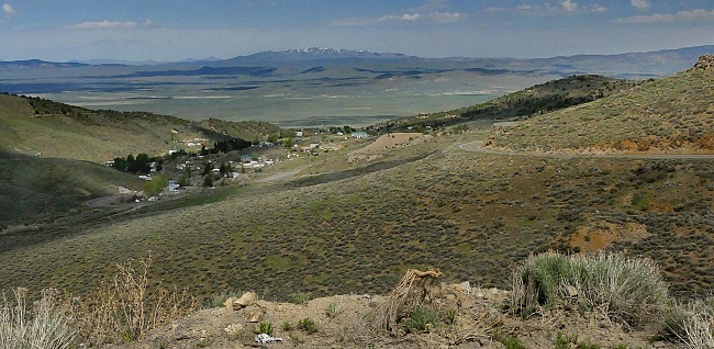
From West. Austin is where the curves on
US50 start, when leaving the expanse of dessert
that is labeled Reese River Valley on the map. But
Austin is not located where the climb starts.
Several hundred feet are involved in climbing the
alluvial fan below the town. Austin inhabitants seem to have accumulated a lot
of junk since the time this was a silver rush
town. Today it looks more like a auto junkyard
with a few buildings lining main street. But
living in isolation like this, and considering the
prices one has to pay to buy anything whatsoever,
this is just smart thinking. But the buildings of
Austin are even older than the oldest, rustiest,
most banged up, deadest cars in town. Billboards
on the outskirts of town make it sound like one is
approaching a tourist attraction. I guess it's all
in the marketing. The old historic city hall does
have a small pamphlet with several mountain biking
trail rides. As far as stores and groceries are
concerned, there are two gas stations competing in
who can charge more for gallons of gas and milk. Leaving the junkyard behind, the road climbs into
bare green hills and gains the top of this summit
with two or three switchbacks. On top dirt roads
in both directions are amongst the mountain biking
routes, suggested by the official pamphlet.
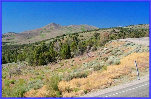
From East. (described downwards) A short
descent leads to a high valley with flat topped
mountains in the background. Then another short
climb leads to what is labeled "Bob Scott's
Summit" on state maps. Unlike all the other
official US50 summits, this one has no name sign.
But it does have an oversized parking lot and a
historical marker on top. Bob Scotts Campground,
immediately after the top, has water and charges
10 dollars a night. The remaining descent goes through plenty of open
trees, until the dessert scape of Big Smoky Valley
makes it appearance as backdrop. The view of this
massive valley, lined with the rounded triangles
of the Toiyabe Range on one one side, and the
Toquima Range receding into a wooded plateau on
the other side, to me is more impressive than the
pass itself. Unfortunately, during the time of
year I was here, it was also much hotter and less
comfortable. Again the bike keeps on rolling well
into the valley, when the mountains have already
become a distant sight. Dayride with this point as
highest summit: COMPLETELY PAVED: ( < Carroll
Summit | FR489
Simpson Park Mtns s(u) > ) Austin Summit x2 , Bob Scott
Summit x2 : campground on Bob Scott Summit
> US50 east > out and back on Grass Valley
Rd << turnaround point after ~5+1/2miles
after surface has deteriorated to mostly dirt
>> Austin Summit <> Austin <>
out and back on Nv305 north << turnaround
point after ~12miles at 5690ft <> out and
back on Big Creek Rd towards Big Creek campground
<< turnaround point end of paVement after a
few miles >> Austin > Austin Summit >
Bob Scott Summit <> separate out and back on
US50 east with turnaround point ~500ft below
summit : 60.1miles with 4320ft of climbing in
5:37hrs (garmin etrex32 r4:23.5.23). A Dayride with this point as intermediate
summit is on page: FR002
Toiyabe Range s(u)
|

 Approaches
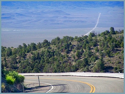
|
|
advertisement |
|
|
advertisement |