| |
| |
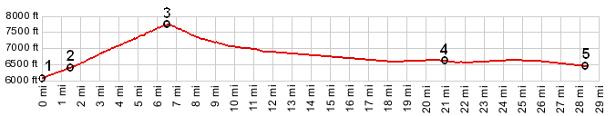
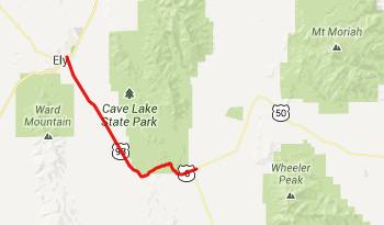
Connors Pass
Between the Sevier Dessert in
Utah and Ely, Nevada US50 crosses three summit
points. Two of them are named passes. This is the
most westerly of the three, also the most
forested, least dessert like and the highest of
the three. It affords great far views of Wheeler
Peak in Great Basin National Park.
From East. Spring Valley, where this
approach starts, is arguably the scenically, most
interesting spot along the entire route. But every
time I have been here, it has also been the most
windy. A hot dessert wind blows up from the south,
flowing up a valley, shaped like a giant rain
gutter. Starting the shallow climb up the alluvial fans
to the entrance of the canyon improves the view
point onto the surrounding scenery drastically.
US50 does this between the junction with Osceola
Road and a location called Majors Place on the
map. Majors Place is a bar. Entering it feels like
descending int a civilized cave of sorts, with
dollars pinned to the walls, compared to the
bright hot outside during June. They are friendly
enough to fill up my water bottles - thank you. I
imagine every cyclist passing along stops here for
water, so they may get tired of it at some point. From here the road enters Juniper Forest and
gradually gains the top, needing only large radius
curves. The wind here is often straight from the
west, which makes climbing slower. Two spots lend
themselves to admiring Wheeler Peak, across the
valley in the Snake Range. Immediately below is
the road bed of a former pass crossing. The top is
a forested expanse with dirt roads and piles of
road construction materials on both sides of the
road. 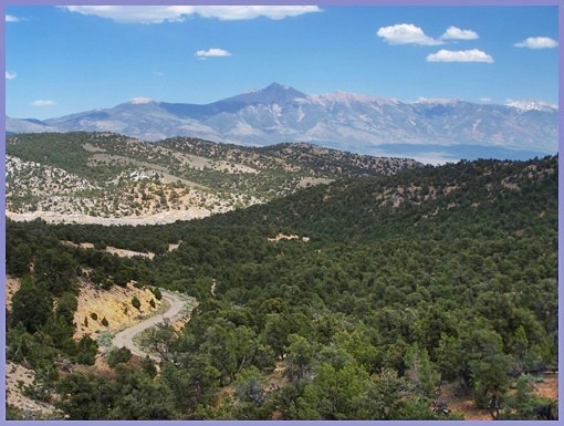 From South. (described downwards). Not
much happening on this side scenically - just a
bunch of juniper trees. Mysteriously, the shoulder
starts to be rumble stripped part ways down this
side. I don't understand the logic behind this.
Are drivers more likely to fall asleep behind the
wheel, as they approach towns the size of Ely, or
is there some sort of logic applied that says
cyclists are supposed to ride in the middle of
traffic as they approach towns. But what am I
complaining about ? I wonder how the guy, towing
the three wheel trailer, filled with camping
equipment across the country felt like. In any case, luckily traffic is so sparse, that
the whole point is a little academic. A long
slightly downward sloping ramp delivers the
cyclist to Ely, often in record speed. The wind
has always been from the south when I was on this
road. A Dayride with this point as
intermediate summit is on page: FR59436 Cooper
Canyon s(u) |
 Approaches
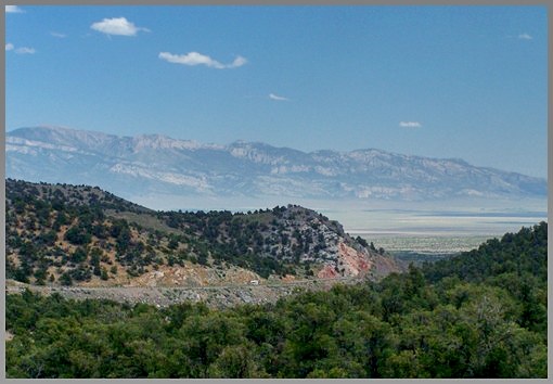
|
|
advertisement |
|
|
advertisement |