| |
| |
Daggett Pass
(aka Kingsbury Grade) Kingsbury Grade Road is a pretty
big climb up out of Carson Valley to the Heavenly
Ski area. All the scenery and the workout seem to
be on the east side, even though Lake Tahoe on the
west side is really the main scenic attraction in
the general area. But from this road you don't see
much of it. Like many roads in this area, this
pass has a wide shoulder, that has not been
rendered unridable by rumble strips, and there are
quite a few people riding bicycles on this
shoulder.
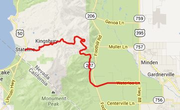
From East. If heading north in Carson
valley on Foothill Road, you can see bits and
piece of this long curving ramp, stacked up on top
of one another. One can imagine already that the
view back down will be pretty good too. Then when you finally work your way up this
series of ramps, progress can be seen in relation
to Job's Peak and Job's Sister (the sister is the
higher of the two at 10823ft). As the road gains
altitude, it makes larger curves, smoothly
contouring along the rounded peaks. Perched high
above, a facade of ski condos appears on a cliff,
closest thing to "something heavenly", like a
temple or a church in Heavenly Ski Area. The Gods
worshiped here are of a different nature. A few
more large radius curves and the road summits at a
turnoff into the condo world of the Heavenly ski
kingdom. You can add another 150ft or so of steep
climbing by turning left here and then rejoining
the Daggett Pass road a few hundred feet below its
summit. An out and back loop along Tramway Dr even
yields a descent view of Lake Tahoe, if you walk
off the road for few feet, and duck in the right
way to avoid cables and condos. 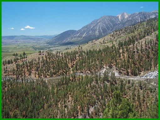 From West (described downwards). A
quick descent with a few fast curves on a big
shoulder speeds into the outskirts of South Lake
Tahoe. Getting the first view of the lake means
you are almost there already, and even then there
are lots of billboards and electrical cables in
the way. A dayride with this point as
intermediate summit is on page: Luther Pass
|

 Approaches
|
|
advertisement |
|
|
advertisement |