| |
| |
Basque Summit
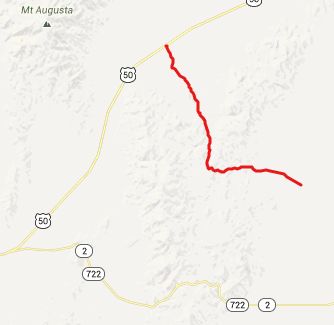
When you follow the old Overland
Road, that was also used by Pony Express riders,
across Nevada, you get a completely different
impression of the state's landscape, than when you
follow modern roads. The reason is, that the major
paved roads stick as much as possible to the
dessert valleys. The Overland Road had to try to
be more "horse friendly", seek out the woods and
the streams for water. For a cyclist too, this can
can be an attractive alternative, when the
desserts are hot, which is often.
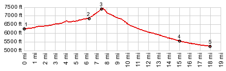
The majority (if not all) of the route profiled below, follows a portion of this old Overland Road. This route goes over private land that belongs to the Smith Creek Ranch. But the owner gives public access to the road from the north. In addition I also happened to ride through this ranch on the southern approach. But there is a way around this. More below.
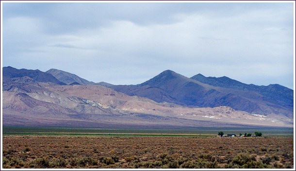
From South. In Smith Creek Valley two
gravel roads meet on the north west side of a salt
sea bed. The de Lorme Gazeteer does not give them
names. But it does label the reason for the
existence of these two gravel roads: the Smith
Creek Ranch, a few miles to the west of this
junction. The profile starts at the point, where
the northern part of this "Smith Creek Ranch Rd"
exits the salt sea bed. The route starts to
approximately follow the Overland Trail at the
junction of these two gravel roads. During my ride I rode through the ranch property.
The owner happened to be there and told me to
continue up the road through his property. The
locked gate along the way is easily detoured with
a bicycle. But there is also another public access
route to the south. But the turnoff is not labeled
and difficult to find on first try.
Once past all the mostly empty ranch water
reservoirs, a good, easily bikable dirt road heads
direction Basque Summit. The name "Basque Summit"
seems to be used for both the small mountain
behind the highest part of the road, and also for
the road itself. The first right continues the
climb. It tops out at a cattle corrall, with
another dirt road joining from the left. Basque
Summit, the mountain, remains mostly hidden in the
trees to the west From North. (described downwards)
Immediately after the summit point the general
direction of the route makes a 90 degree right
turn, and now heads north. But with the Desatoya
Mountains angeling off to the north west, it is
easy to get confused. After a short descent signs
tell the story of the Edwards Creek Riparian
Restoration Project. Who would have thought, that
not far from a valley so dry that it contains a
salt sea bed, all of a sudden, I would lament the
fact that I don't know more about bird calls.The
bird sounds coming from these big wet bushes were
positively puzzling, and had nothing to do with a
dessert but everything with a swampy area, teeming
with wild life. Immediately after, just where the map says, there
should be an old Overland Mail Station, stands an
old wood ruin, picturesquely rotting away with its
accompanying out house at a hygienic distance. For
all I know this really are the remnants of the old
Mail Building, although the construction methods
used for this building seem more modern. If this
is the location of the old Mail Buidling, they
picked a very picturesque spot, just where the
Overland road exits the confines of the intimate
canyon, and spills back out onto the alluvial fan
of the expansive dessert. Just as there are no
road signs anywhere along the route, there are
also no signs near the building. After a few miles the route separates into
separate rays shooting towards different junctions
with US50. On my route I wanted to complete the
loop towards the north, so I stayed left. The
profile takes the option on the right which
reaches a little lower. Dayride PARTIALLY PAVED / UNPAVED ( < Austin
Crest Trail s(u) | Luther Pass
> )
|
 Approaches
|
|
advertisement |
|
|
advertisement |