| |
| |
Sacramento Pass
Sacramento Pass is Nevada's most
easterly summit on US50. It connects the amazing
emptiness of Snake Valley with a more photogenic
valley, Spring Valley. Along the way it passes the
peaks in Great Basin National Park, including
Wheeler Peak, 13063 ft, albeit at quite a
distance.
From East. On a bike tour you would be
better off coming down this way, because of the
usually strong, westerly winds. But my route
happened to go up this side, so this is the way I
will describe it. East of the pass, Snake Valley
is such a large, sweeping emptiness, that it
becomes monotony, verging on the spectacular. An
undeveloped entrance to Great Basin National Park
has a pleasantly understated appearance, when
compared to the circus atmosphere of many, more
famous parks. The road travels up the shallow
slope of the alluvial fans, surrounded by
sagebrush hills. Slowly, to the left, the highest
peak in Great Basin National Park begins to show a
sliver of a north face, a hint of a high alpine
world behind slopes of brush forest. In June there
are only specks of snow left even on the highest
peaks. At the junction with Osceola Road a small
sign gives a short, but concise history of the
area and the pass. As the road approaches the summit, the straight
line of the road becomes concave downward, going
over the summit in smooth parabolic regularity.
There is a sign on top, that can be seen for quite
a distance before passing it. 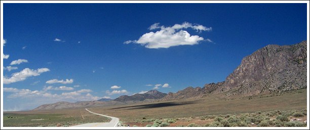 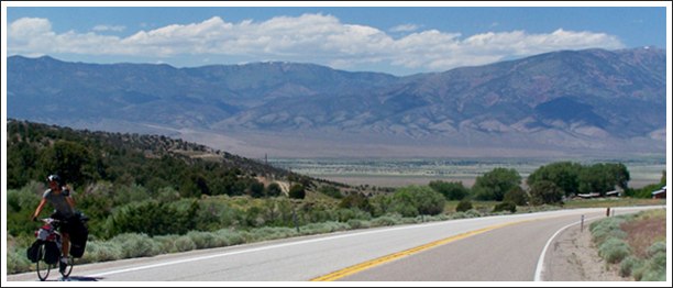 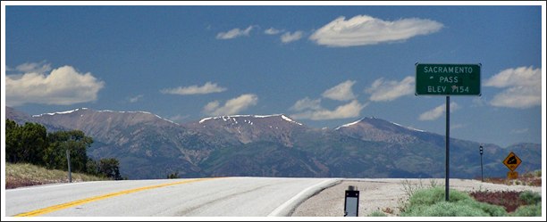 top: the last descent into Spring Valley middle: going west to east with Spring Valley in the background bottom: the top From West. (described downwards) One
large sweeping curve is the stage for the visual
introduction to Spring Valley, I think one of
Nevada's most impressive sweeping panoramas. The
road passes one farm house of sorts on the way
down, but the valley itself appears devoid of
human signs - for now, just a sign stating "Spring
Valley", about a quarter mile from the road. The
distance between the sign and the road seems in
proportion to the size of the valley itself. The road rounds an impressive rock outcrop to the
south, and then - surprise - a gale force head
wind blowing in your face like a furnace that's
gone cracy - at least that was my experience
during a ride in mid June. To add another insult,
there is a small climb here too - just as the
signs of human habitat, or more correctly
intervention, become more apparent. The road makes
it's way by a large wind farm, that is harvesting
the same force that's making life difficult at the
moment, the aforementioned strong hair dryer
breeze. A right turn at the junction with this end
of Osceola Road leads to a section of US50,
crossing the valley straight as a ruler. On the
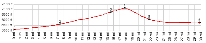
bike it feels like the profile reaches a low point
immediately after the jct with Osceola Rd. On the
profile it looks like the real low point is
located before this turn.
Historical Notes Early Cross Country Routes. Today this
pass carries the majority of traffic through this
part of Nevada. But historically another crossing
to the north was more popular, Schellbourne Pass. Sacramento Pass is mentioned in several sources
as being scouted by Howard Egan in 1855 in order
to drive cattle from Utah to California. Later
this general route became the most important
transportation route for a decade, before the
transcontinental railroad was finished. But
Sacramento Pass was not the first choice for this
route. Again Schellbourne Pass to the north, today
a dirt road, was more commonly used. Still, this history of this gentle gap is closely
tied to the "Central Overland Route", as this road
between Utah and California became known. In 1857
and 1858, there was a confrontation between the
state of Utah and the US federal government. On
this occasion, one of lieutenant James
Simpson's tasks was to resurvey a route from
south of the Great Salt Lake to Genoa, Nevada. He
generally followed Egan's old route, again using
Schellbourne Pass instead of Sacramento Pass, but
he did survey Sacramento Pass. On this occasion
they also climbed Wheeler Peak. Following the
survey, the army built a wagon road over
Sacramento Pass. US50 stays south of the Central
Overland Route until they touch again on Emigrant Pass.
Modern Roads. During the time when naming transcontinental automobile routes became a popular thing to do, the the first such named coast to coast route, the Lincoln Highway, also used Schellbourne Pass. It took until after WW2 for Sacramento Pass to be included as part of US50, It was the paved in 1947. During this era a roadside Inn stood near today's junction with Osceola Road on the east side. It served ranchers and miners until the 1960s. Gas was also available nearby. Today cyclists detour away from US50, to Baker and Garrison, just to get water. A Dayride with this pass
as intermediate summit is on page: Osceola Road
s(u)
|
 Approaches
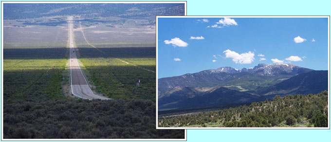

|
|
advertisement |
|
|
advertisement |