| |
| |
Bear River Plateau -1(sh)
The name Bear River Plateau
describes this land feature well. On three sides
it is bordered by the Bear River. Yet no sane,
normal tourist would ever get off the paved roads
and explore this sagebrush covered noman's land.
... for the most part. Even if I didn't see any
other tourists, and no vehicles on the dirt tracks
between unsigned intersections, given the right
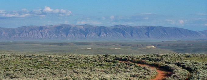
weather conditions, there are some impressive
expansive views here, that mostly only ranch
people seem to know about. But mostly this is a
diverse wildlife area.
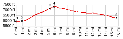
At the summit of the Ut30 road the profile turns
on an unlabeled BLM road to the north. At the
first intersection the left track is labeled as
"restricted walk-in access". The profile stays
right and reaches a high point at the next
intersection. At least it is a high point if you
take a right here. The other two tracks reach
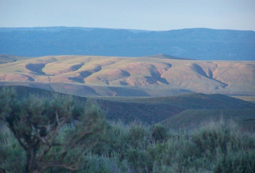
higher but are less used. This summit point has a panoramic view, made up
of building block dessert landscape features. To
the west the low ridge, ruffled like a curtain:
the Bear River Divide; behind that the high snowy
source of the Bear River: the Uinta Range. To the
east, a thin snowy line at the horizon: the Bear
River Range. Almost everything's got a Bear in it.
But today you see only cattle or Rattlesnakes.
From East. (described
downwards). The way down the east side to a ranch
is the route that I recorded with my gps. There is
a maze of ranching tracks here. The ones I
followed are the more easily ridable ones.
Waypoints along the way are: the occasional
watering tank for lonesome cattle in a sea of
sage, or the occasional stick of salt stuck in the
ground for the mineral hungry cattle. "Watch out
for the gigantic gopher holes" I kept reminding
myself. Without a gps I would be afraid that this
track would end behind every next corner at some
stinking cowpit. With a gps I was still wondering
about this possibility. But I was happily
surprised: the route went through. The last part is a scenic descend above the Bar-something Ranch - available for groups between 30 and 100 (according to the sign). That size requirement should cover the majority of Mormon families. - In a way American ranches are like European hill towns. There must be 1000s of them, and most are in such isolated areas, that you still have a sense of discovery when you encounter one in an especially scenic setting during a bike ride. But maybe the feeling of being wellcome is more pronounced in many hilltowns. To get to the nearby visible paved road, I had to cross a gate and walk across a field. The paved road (named Manhead Road) leads to the Bar-something ranch. Dayride with this point as highest summit: PARTIALLY PAVED / UNPAVED ( < Bald
Mtn Pass | South
Eden Cny - North Eden Cny(sh) > ) Bear River Plateau -1(sh) , Bear
River Plateau -2 s(u) , additional out
and back: Bear River Plateau -1(sh) >
down unmarked tracks as shown on profile <>
out and back for a short distance west on Manhead
Road >> Manhead Road east > Six mile road
north > following unmarked roads shown on Bear
River Plateau -2 s(u) profile west > down South
Eden Canyon Rd > Cisco Rd north along shore of
Bear Lake > Ut30 east > unmarked dirt road
back to starting point: 45.2miles with 2560ft of
climbing in 4:34hrs (garmin etrex30:17.6.14).
|
|
|
advertisement |
|
|
advertisement |