| |
| |
King's Wells Road -1 s(u) Surprise- this point turned
out to be the highest point, one on a loop
ride in the maze of gas well roads, with
mostly excellent bikable surfaces, in the
Bookscliffs area, that adjoins or is part
of, the Uinta Basin in Utah. Other points
on the loop ride below offer more
interesting scenery than this one.
From West. The approach starts at a big signed intersection in the maze of the Uinta basin mining roads. Two of the intersecting roads are CR4160 Asphalt Wash, and another is CR4190 Kings Wells. The profile follows the Kings Wells Road in a straight shallow climb to a plateau top. It almost appears like a plain on top From East. From the intersection at the top, the road descends into a bleak shallow canyon, just about 500ft drop, only to repeat the exercise with the next summit Kings Wells Rd s(u) -2.
Dayride with this point
as highest summit:
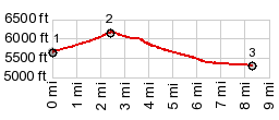
COMPLETELY UNPAVED ( < White River West Rim-1 s(u) | Cold Springs SWA(sh) > ) CR4190 Kings Wells -1 s(u) , CR4190 Kings Wells -2 s(u) , CR4190 Kings Wells Rd - CR4180 Dragon Rd(sh) , CR4170 Southam Canyon Rd s(u) : ~.5miles from jct Ut45 - Southam Canyon Rd > Southham Canyon Rd s(u) > Asphalt Wash Rd south > CR4190 King's Wells Rd east > CR4190 Kings Wells Rd -1 s(u) > CR4190 King's Wells Rd -2 s(u) > CR4190 Kings Wells Rd - CR4180 Dragon Rd(sh) > CR4180 Dragon Rd north > back to starting point on Southam Canyon Rd : 43.8miles with 3640ft of climbing in 4:28hrs (garmin etrex30 m3:20.5.17) Notes: first ride this year that was definitely tooo hot. 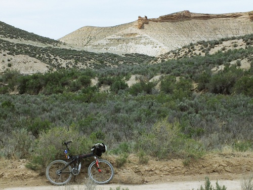 |
|
|
advertisement |
|
|
advertisement |