| |
| |
Cold Springs SWA(sh) This road crosses a very
impressive Utah landscape, that is rarely
visited by people on bicycles. But that is
not surprising. Utah has so many types of
landscapes (and Moab is such a comfortable
place, to hang out). This shoulder summit
is very close, to what may be (as far as I
know) the highest road point on the West
Tavaputs Plateau: Bruin
Point. When combining two approaches
to Bruin Point from Nine Mile Canyon, the
point described here becomes the two-way
summit, and Bruin Point is a short out and
back from there.
The gentle grade takes an
abrupt end at a 90 degree right turn in the
road. The next climb was steep enough, I
walked most of it. Signs instruct truck
drivers to communicate their intentions of
taking "the dugway" on C band radio, in
order to avoid oncoming traffic. I only saw
only a single motor vehicle on the entire
loop, and it was not a truck. At the top of
this first steep section the road emerges on
the the first wide rolling shelf of the
plateau. The way to the top becomes visible
soon after that. At the next (unsigned)
intersection, it is clear that the way to
the top continues straight through the brush
forest. This is another steep section.
But once on top, all the mesas with their
peculiarly bright, creamy Uinta Basin colors
recede in waves to an endless background.
These open treeless miles on top is arguably
my favorite section on this loop. Soon the
transmission tower on Bruin Point becomes
visible, and the traverse to get there,
looks more scenic than work. But that can be
deceiving, especially in May. The road
enters the lower part of the Cold Springs
Wildlife Management area. With that comes
more trees, more shade and more mud, and
also more snow - sometimes a lot more. The
last several miles of the climb are in
juniper forest and the open vast spaces of
the dessert seem as far away, as they
apparently are. Near the summit an outbreak
of private landowner signs, fences and
warning signs leave an unpleasant taste. The
route joins the other approach to Bruin
Point, coming up from the south, and then
reaches a high point at the turnoff down Dry
Canyon. Bruin Point is a couple of hundred
feet higher, but the profile turns down Dry
Canyon. From
South. (described downwards). The
first several miles follow the plateau edge,
but in the forest. Consequently the snow
lasts to an even lower elevation than on the
north side. A swerve in the road to the
north helps loose elevation and gain warmth.
Finally the road traverses the bottom of a
pleasant green valley. After miles of this
comes the last section: red canyon walls
rising on both sides, now and then a
Cottonwood tree positioned in a picturesque
spot on the valley floor. The mud is
starting to cake off the bike. Yes - and it
is starting to feel hot again, but the water
in the bike bottle is still ice cold. Again
the most impressive canyon section is the
lowest part. The lower part of this road is
in good shape again, due to gas wells along
the way. The upper part could be described
as a very easy jeep trail. There is a
compressor station at the canyon entrance.
Dayride with this point
as highest summit:
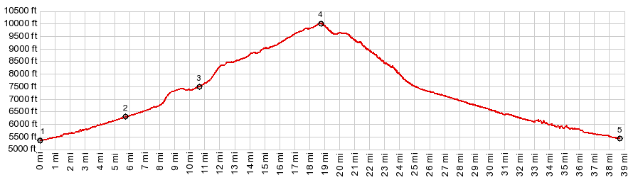
PARTIALLY PAVED / UNPAVED ( < CR5190 King's Wells Rd | Gate Canyon s(u) > ) Cold Springs SWA(sh) , additional out and back: at ~6220ft on Gates Canyon Rd > down Gates Canyon > Nine Mile Canyon east > up Cottonwood Canyon > up Cold Springs Draw Rd > Cold Springs Draw SWA(sh) > down Dry Canyon > Nine Mile Canyon west > back up to starting point in Gates Canyon : 57.1miles with 6990ft of climbing in 7:09hrs (garmin etrex30 m3:20.5.19, t20_02) Notes: very windy, much snow and mud over the top on both sides, hot in the canyon bottoms, a great day |
|
|
advertisement |
|
|
advertisement |