| |
| |
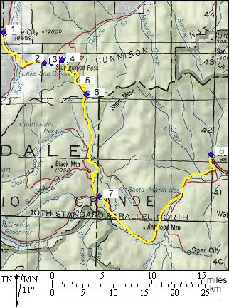
Slumgullion Pass / Summit
Slumgullion Pass is not really an
"alpine" pass, passing by vertical "alpine" cliff
faces. The vertical peaks are further away in the
Uncompaghre Range and the Molas Caldera to the
north west. I think its appeal lies more in the
variety of landforms - some near, some far, and
its relative isolation.
San Juan paved passes seem to come in pairs. This one is paired with Spring Creek Pass. The latter is a more inconspicuous crossing in a forest clearing. But it is where the Continental Divide crosses. There is a question to the exact
location of Slumgullion Pass. Helmuth's book
"Passes of Colorado" points out, that topo maps
place the summit onto dirt surfaced FR788, 1/4
mile to the northeast. That summit is on the Slumgullion Pass
alternate summit page.
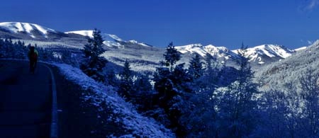
From North. Lake City is a special little
town. It is a place where you could argue, that
not much has changed since the late 18 hundreds,
at least from a superficial visitors standpoint.
The town's main street still has its fake store
front houses. The arcade of trees lining the main
thoroughfare through town has become much larger
though, and more impressive looking, but that is
even an improvement. The road out of town has no shoulder, but traffic
has always been light and friendly in my
experience. After one or two rolling hills,
passing Lake City's "ski hill" (that's what the
sign reads), the first memorable views are of Lake
San Cristobal, an uncharacteristically large lake
for Colorado Rocky proportions. Like most lakes it
was formed by a mudslide. The best view point comes further up. It requires
a slight detour to something named Windy Point.
From there, the eye can wander across the valley
of Henson Creek and up the lower Engineer Pass road.
Across the valley to the north are a few curious,
isolated shapes above treeline. They are the peaks
of the Big Blue Wilderness, some with names
inspired by other famous triangular peaks:
Wetterhorn Peak, Matterhorn Peak and Uncompaghre
Peak. A little more climbing and the road curves
between more rounded shapes to reach the summit.
The turnoff to a dirt road with the alternate
summit is just 1/4 mile before the top to the
east.
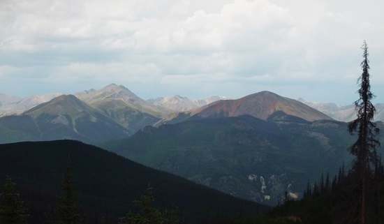
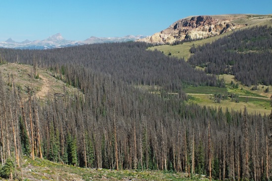
From South (described downwards). The
scenery changes on this side of the pass. The next
peak to the south impresses with its absence of
rocky faces, yet large rounded proportions. Baldy
Cinco ( call it "hairless mountain number 5
-13383ft" ) stands at the entrance to the La
Garita Wilderness and its high tundra plateaus.
After a few girating curves, and the road reaches
a low point at the crossing of Cebolla
Creek. After a dirt road turnoff the road
starts climbing again to Spring Creek Pass.
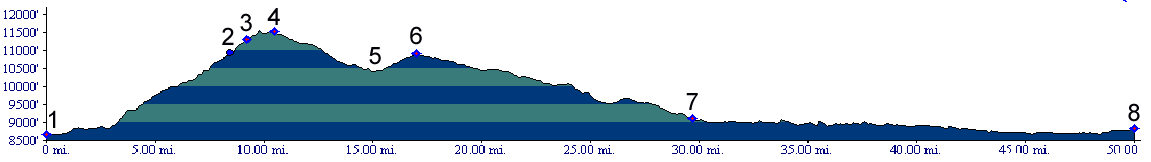
Dayride with this point as highest summit: PARTIALLY PAVED / UNPAVED: Slumgullion Pass, Slumgullion
Pass alt summit: Top of Nine Mile Hill
(Co149 several miles south of its junction with
US50) > Powderhorn > Cebolla Creek Road >
Slumgullion Pass alt summit > Slumgullion
Pass(shp) << turn around point: low point
between the Co149 Slumgullion Pass and Spring
Creek Pass summits > Co149 south >
Slumgullion Pass > Lake City > back to
starting point: 94 miles with 7500 feet of
climbing in 8.0 hours (m3: 5.7.18).
COMPLETELY PAVED: ( < North
Cochetopa Pass | Elwood
Pass > ) Slumgullion Pass, Spring Creek Pass:
Lake City > Slumgullion Pass >
Spring Creek Passes > Creede: 53miles
(mechanical odometer: m1:87.09.7) . Rides with this point as intermedate summit are on page: Colorado Trail
m363.1, section: Spring Creek Pass - BLM3323
s(u)
History The route approximating today's
Slumgullion/Spring Creek pass road is ancient. But
the name "Spring Creek Pass" is relatively new.
Originally a Ute trail, some version of the pass
was used as a summer crossing by Bill Williams,
Antoine Leroux and other Taos trappers on their
way to Gunnison country, serving as an alternate
route to the Cochetopa
Pass area crossings. They called the
route "summer pass" . An army map of 1851 referred
to it as "Pass of the Rio Del Norte", meaning the
Rio Grande. The Hayden Survey As if the various names
and locations of these crossings weren't already
confusing enough, the origin of the name
Slumgullion is further reason for confusion. The
word Slumgulliom sounds interesting enough. But
what does it mean, and where did it come from ?
Helmuth's book "Passes of Colorado"
attributes the origin of the name to the Hayden
Survey. Accordingly the color of the hardened
mudflow debris, that blocks San Cristobal Lake,
reminded them of the color of their meat stew
which happened to be named Slumgullion in 1874.
Marsall Sprague in "the Great Gates" also connects
the name to the color of the mudflow damming Lake
San Cristobal. But according to him, the name was
already established, and dates back to New England
pioneers. The color reminded them of "the
mulitcolored refuse of a butchered whale". In
conclusion - it seems to have something to do with
stew meat. The Leadville Boom (<Black Mesa
summit(u)|Engineer
Pass>) The excess of miners in the
Leadville area was so great, that demand for more
land to dig up, lead to thoroughly disturbed
mountain sides in the San Juans. Amongst the
people who profited from this trend were the toll
road operators. In 1879 Del Norte's toll road over
a route approximating today's road over
Slumgullion and Spring Creek Passes was one of two
toll roads to Lake City. The other toll road was
Otto Mears Cochetopa
Pass - Blue
Mesa Summit - Cerro Summit
route. The Del Norte - Lake City road was called
Cebolla Pass, for one of two creeks headed by
today's Spring Creek Pass. One guess as to the
name of the other creek headed by that pass !
|
||||||||||||||||||||||||||||||||||||||||||||||||||
 Approaches
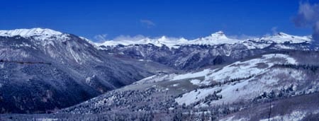
|
|
advertisement |
|
|
advertisement |