| |
| |
North Cochetopa Pass
On first look North Cochetopa
Pass is on the long, pleasant, somewhat empty,
less than spectacular Continental Divide road
crossing between Saguache and Gunnison. Much of
the road has no shoulder, and this is really of
little consequence, that's how little traffic
there is. The pass is a newer highway version,
north of the historic Cochetopa Pass,
which crosses five miles to the south. The "North
Cochetopa" is shortened on many maps to "North
Pass". This can be confusing. Famous "South Pass"
in Wyoming,
is hundreds of miles north of "North Pass".
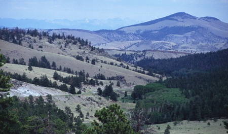
From East. Co114 leaves Saguache
following the valley of Saguache Creek. The
distant wall of the Sangre de Cristo mountains
slowly disappears behind hills featuring gray lava
cliffs, tilted in all imaginable directions. The
almost imperceptible climb becomes real at the
junction where the old Cochetopa Pass
branches off. The hills leading up to the
continental divide are like a gentle roof covered
with a rumpled blanket. The eyes sweep to the
horizon across a dissected, slanted plain, picking
up discrete, widely spaced trees along the way,
finally latching on to a rounded mountain above
treeline. The top of the pass is forested. But the
Sangre de Cristos can be spotted from several
locations on the approach.
From West. (also described upwards) The
profile starts with the shallow approach through
Cochetopa Canyon. The deepest and most scenic part
of the canyon directly joins to the lower end of
this approach. The North Cochetopa biker gets a
short version of the high La Garita Mountain views
before Cochetopa Creek takes off towards Cochetopa
Pass for the long version. After that the road gently rolls over hills, the
occasional herd of cows making up the most lively
highpoint of the journey. Just when you think that
this must be the gentlest continental divide
approach in the state after Muddy Pass,
a sign advertises the summit two miles away, and a
short climbing workout is in order after all. The
Colorado Trail and the Continental Divide Trail
cross the road about a mile west of the top.
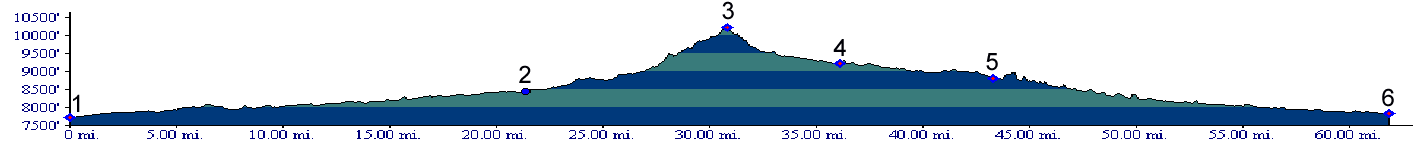
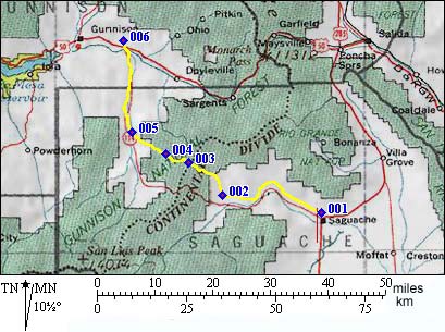
PARTIALLY PAVED / UNPAVED North Cochetopa Pass, Cochetopa Pass: campsite a few miles west of Saguache > Co119 west > Cochetopa Pass > jct Co119 - Co125 << back on Co119 > North Cochetopa Pass > Co119 east: back to starting point: 84 miles with 3250 feet of climbing in 6.3 hours.
same summit points : campsite on BLM road
west of Saguache > Co114 west > FR740 west
> Cochetopa Pass <> NN-14 west > Co114
east > Cochetopa Pass > starting point:
84.5miles with 4360ft of climbing in 6:32hrs (m3:
5.7.12)
History. Much of what is described as the
early history on the Cochetopa Pass
page could have happened on today's North
Cochetopa Pass or a drainage close by. The
Hayden Survey mapped this pass in 1877. By the
time regular stage coaches were crossing Cochetopa
Pass, a charter was issued to also construct a
wagon road over this pass. By 1916 a highway
existed over the top.. But it took until 1962 for
the road to be paved. 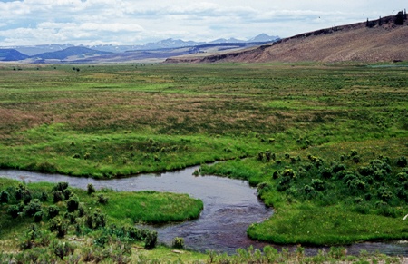
|
||||||||||||||||||||||||||||||||||||||||||||||||||||
 Approaches
 Dayride with this pass as
highest summit:
Dayride with this pass as
highest summit:|
|
advertisement |
|
|
advertisement |