| |
| |
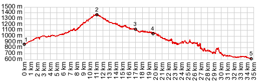
Alto de Fanlo s(u)
This is probably the most
spectacular way to enter the Parque Nacional Odesa
y Monte Perdido, at least if you confine yourself
to pavement and routes that stay under 2000m. But
this is not a heavily traveled tourist road, but
instead a narrow route of potholes. Scenically the
most spectacular part are the two lower options of
the eastern approach, including the Canyon de
Anisclo. But those can be cycled in a loop without
actually having to go over this summit. They are
described on the Vio-Buerba
s(u) page. And then there is the village
Fanlo at the summit ... more below.
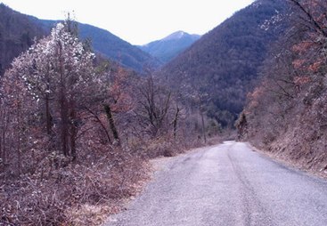
The first change comes when the road crosses the stream Barranco de Jalle. This is becoming a real workout. The road now climbs steeply in switchbacks above the stream. The main ridge of the Pyrenees starts to appear, shaped like a giant pillow draped over a string, as if hung up to dry - a large shape, but not much shape. Climbing higher, you don't ever see the village Fanlo from this side.
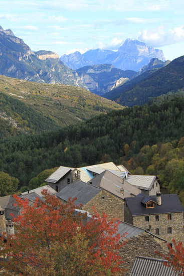
The first time I arrive at the top, the sign at the turnoff is obscured by fresh cow manure and the road is also quite a rainy muddy cow mess. The second time I arrive here is so much better. Now I can see the beauty of this scene. I ride the extra half km above the summit to the village Fanlo. I spend quite a bit of time wandering through the village and also to wait for just for the right light to take pictures. When reading about this villiage, you can get the impression, that this is a real tourist town. However - when I am there, not a single building is open, no other person walks the streets. Neither is there evidence of stores or other commercial ventures. But the multitude of great images on the web of this village are proof, that I am definitely not the first to see the beauty of this location. The short access road leading to the village
approaches it with a traverse, that is slightly
higher than the village itself, so that it is the
perfect vantage point for the landscape down
valley, reaching all the way to the other side of
the Rio Cinca and the block Pena Montanesa. From
here it looks like a block shape, almost like a
volcanic plug. Nothing could be further from the
truth. I reality it is a long limestone ridge,
viewed head on. The mountain shows up in almost
every picture of the village, including the one to
the left. They are all taken with a very long
focal length, In reality it is quite far away, but
it is the essential background for this scene. From East. (also described upwards). There are really two options for the approach from this side, the one shown in the profile through the Canyon Anisclo, and a roughly equally long option, involving more climbing over the Buerba summit. However when coming down you have to go over the Buerba summit, because the Canyon Anisclo option is a one way road, open uphill. Both options are described in the Buerba summit page. The profile contains the canyon option. That part of the profile is a very rough, because it is tough to get a good profile in such a narrow canyon. One spike is also due to a tunnel. Above this junction (between points 4 and 2) the rustic little road is a little more predictable again. The hilltowns between here and Fanlo are further up the north slope of the high valley, so that they can't be seen from the road. Especially tempting is the sidetrip to Nerin, which (as it appears from looking at a map) also gives access to spectacular high Pyreneen MTB routes. On this side Fanlo comes into view from a few km below. The church sits apart from the cluster of houses, below the village. However, you don't get an idea from here, of how much more expansive the view is from above the village. But for all of this the weather has to cooperate, and preferably the cattle do not mess up the road too much.Slideshow of the road between Sarvise and the jct with the Buerba-Vio summit
A Dayride with this point as intermediate summit is on page: Puerto de Cotefablo Notes: I rode the west side a second time as an out and back summit. That ride is on page Los Molinos s(u) The village Fanlo, .5km above the summit:
|
|
|
advertisement |
|
|
advertisement |