This traverse below a vertical appearing
limestone block leads along the outskirts of the Ordesa y
Monte Pedidio National Park. Below lies the old village and
tourist town Ainsa. Not far from the summit a paved one way
climb goes to, what I think is the highest paved point on this
limestone mountain, and also the Hermitage San Victorian, a
landmark church on one of the countless more remote branches
of the Camino de Santiago.
At the turnoff to the the next village - El Casal, a
transpyrenean MTB route also branches off. It continues up the
Pena Montanesa along its the north side, while this profile
follows an easier path on the south side. It traverses below the
cliffs, but still high above the valley of the Rio Cinca. The
mountains on the west side of the wide valley of the Rio Cinca
are partly covered by well defined clouds. They highlight
certain nipple like features on the mountains and hide others, a
wonderful surprise to a day that started with questionable
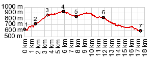
weather. The highest point is reached on that traverse, which
gives an open view of the valley for many kms.
From South. (described downwards)
The route stays at roughly this altitude for quite a while.
Without an altimeter it is fairly difficult to figure out the
highest spot. In Los Molinos the road negotiates between a few
old stone houses, garden walls and sheep herds. In this area a
signed turnoff leads up a steep climb on a remote road to San
Victorian. A little later on the shallow descent, from below, the church
San Victorian appears to be perched precariously on a limestone
cliff above. But in order to see it, you really have to stop and
look upwards for a tiny spot where the power lines aim for, from
far below. In a car you would have to get out, or cut off
the roof. The lower part of the descent goes through a soft shale that
forms badlands and erodes into pagoda like shapes. This is the
only part of the trip where I took many pictures, the likes of
which I cannot find on any photo sharing sites. For me
personally, this part of the ride is a reminder of the Utah
landscape, but without the gun shooting ranges and jeep tracks
in the dessert. The profile ends, where this side road meets newly
constructed N260 between Anso and Collado
Foradada, below the little village Arro. This collection of
a handful of houses on a cliff has a modern addition, a water
tower, but made out of stone, so that I am tempted to ask
myself: Did they have watertowers in the middle ages ? Well - no
they didn't - not this kind anyway. Sidetrip to San Victorian. Immediately after the
summit a steep one-way climb leads to what I think is the
highest paved spot on the Pena Montanesa. The goal is the
hermitage church San Victorian, that is one of the many Camino
Santiago landmarks. The road appears to head in the wrong
directions at first, straight for a farm. But then before
reaching it it passes between a couple of old stone houses in
Oncins, one looks like an Inn for pilgrims. Then it makes a
sharp right, the road surface improves all of a sudden, and then
for the last km or two, it traverses flatly, as if in a
celebratory mood, over to the hermitage church. For me the
church is closed, but the man behind the heavy wooden doors has
no problem accepting a large, previously announced tourist
groups. From the outside the surrounding ruins make it look
abandoned, a scene from an old romantic landscape painting - not
necessarily anything, anybody would inhabit. Trails continue
from here up the Pena Montanesa, and it becomes apparent, that
from this side, it is not nearly as vertical, as it seems from
previous points of the ride. Instead you can actually hike up
it, going partly through green pastures.
A Dayride with this point as highest summit: ( < Buerba - Vio s(u) | Collado Foradada > ) Alto de Los Molinos: Ainsa > Labuerda > Escalona > Laspuna > Alto de Los Molinos <> out and back to Oncins > San Victorian >> Arro > sightseeing around Ainsa > back to starting point. Notes: gps and distance data is on stolen computer. |