| |
| |
Collado Foradada
This definitely does not seem to be
one of the favorite passes for cyclists. It's a
straight modern road with a wide roadbed, or in
terms of things, that I am familiar with - it's a
highway. I have more than enough of those where I
live. The road is part of the Eje Piranaico, the
principal route along the Spanish Pyrenees. All
that being said, traffic is light and the ride is
really very pleasant. There is still plenty
to keep me busy not far from the side of the road,
small villages and a huge limestone cliff.
The appearance of the Pena Montanesa keeps
shifting. Hard to believe, that this is the same
landform that looks almost like a plug, but
definitely like a block of a slanted plateau, from
Alto de Fanlo. On
this ride it becomes clear that this is a steep,
curvy, very elongated limestone ridge. Stretching
up its slopes are a few farms, and at least one
little village next to the road, that is not on my
maps. The pass itself, passes a low saddle between the
Pena Montanesa and a low ridge branching away from
it. The road over the top is straight as an arrow,
and there are some monuments with puzzling
abstractions along the way. With good weather and
a good telephoto lens there are far hilly views in
three directions from the top.
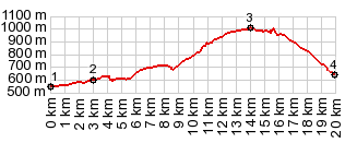
From East. I have to
admit that I remember this as a big wide highway,
and the steepness of the profile on this side at
the bottom surprises me in retrospect. But then I
only rolled down it. You always remember the
climbs better. The profile ends in a puzzling
spaghetti salad of highway intersection ramps, at
what seems just a simple intersection. Traffic
from here on in both directions is heavier. My own
route continues north to Campo through a tunnel
A Day on a Tour with this point as intermediate summit is on page: Collado de Fadas |

|
|
advertisement |
|
|
advertisement |