| |
| |
Buerba - Vio(sh)
These two approaches are often
considered options to ride up the east side of Alto de Fanlo s(u).
Putting them together in a single shoulder summit
loop is a concentrated scenery experience. You
could not pack any more of it into 32 km. I spent
more time stopped taking pictures than actually
bicycling. This entire route is inside the Parque
Nacional de Ordesa y Monte Perdido.
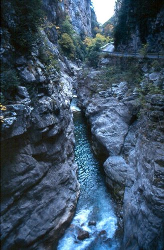
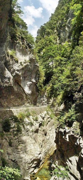
The road enters a slot canyon. For a while the
snow capped mountains, east of the Rio Cinco
appear framed by a very large open door frame. The
road stays very close to the bottom of the canyon.
Large alcoves are required to accommodate the one
way traffic moving at cycling speed. Somewhere
close to the middle of the canyon, the road
traverses a short tunnel in combination with
several alcoves. I take advantage of being able to
stop my bike at whatever place I choose, and get a
few pictures that are not so obvious to drivers.
The subject is the tunnel portal from some
distance with various different pieces of road and
alcoves leading towards it. These are about the
only motives that I remember, which I cannot find
on the web.
At the point where the road starts to climb out
of the canyon is a major trailhead and also a
parking chaos. In comparison the road is
actually very devoid of moving vehicles. This is
the end of the one-way section. With a few ramps
and switchbacks the road climbs to the junction
with the road coming down from Fanlo. It starts to
give the first hints of what this all will look
like from further up.
I too take many pictures of this grandiose scene,
and this just may be the most photographed
mountain scene in Spain. I picked a few favorites
from the web, most of which have better light than
I do, during the two separate times I visit this
scene. The rustic road keeps climbing and the
summit seems to be waiting behind every wave in
the road and after the very next vantage point
onto the canyon. I seem to remember several false
summits before I get to the real one. From East-2. Vio is
another heavily photgraphed spot, and deservedly
so. It can be reached by a dirt turnoff from the
summit. The paved road passes by a small
collection of houses around a church tower, named
Buerba. There is a hostal and restaurant here, but
no grocery store. The vegetation here consists of low bushes and
loosely spaced needle trees, giving off a fairy
dry appearance, and the name Sierra Seca verifies
this impression. The road contours around these
low ridges, near their top, in the background
three white monoliths, with a constantly shifting
foreground. Here I take more pictures, which are
not on any of the photo sharing sites. It is just
easier for cyclists to stop here, than for cars.
For the final descend the road stays on the east
side of the wide valley carved by the Rio Cinca.
The road winds around one last village perched on
a cliff below, that doesn't seem to be labeled on
my maps. On the opposite side Laspuna forms a line
of houses between a cliff below and a rock ridge
behind. The profile meets the starting approach,
so that it returns to the roundabout norh of
Escalona.
Pictures below : Canyon de Anisclo
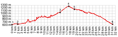
Dayride with this point as highest summit: COMPLETELY PAVED: ( < Puerto de Cotefablo | Los Molinos s(u) > ) Buerba -Vio (sh) , addtional out and back : Ainsa > A138 north > up Canyon de Anisclo <> out and back to Fanlo >> Vio Buerba s(u) > A138 back to Ainsa Notes: gps data is on stolen computer. A Day on a Tour with this point as intermediate summit is on page: Puerto de Cotefablo Pictures: Between Canyon de Anisclo and East-2 start point
|
|
|
advertisement |
|
|
advertisement |