| |
| |
Hurricane Pass
We would never have the roads, if
we would not have the mine tailings - and mountain
bikers would be poorer for it. Hurricane Pass is
an extraordinary road, one of at least three
bikable passes that criss cross this area in a
great alpine environment. And then there are also
the mine tailings, which make rich pickings for
amateur garbalogists. Actually, the idea that you
can't have one without the other, the road without
the mining waste, implies that the mine tailings
could never be cleaned up. This is a sad thought,
but probably realistic when seen in a local
historical context. There is another way to look
at the mines. These old dilapidating buildings
with their accompanying decay have such a strong
cultural connection with this part of the San
Juans, that it is actually hard to imagine this
part of the mountains free of debris. They add
something to the area, in the same way that
industrial architecture can add something to a
city.
Anyway - without the San Juan mining boom of the 1870s Hurricane Pass would not exist. Nobody else would have seen a reason to build it. But the role of Hurricane Pass as a double summit in conjunction with California Pass is a new development. All maps, including the ones shown on informational signs along the route, show the pass as road leading up Cement Creek, ending at the summit, without connection to California Pass. These maps only show the more southerly direct connection to Poughkeepsie Gulch. The answer to the mystery: While historically relatively insignificant, their role in bringing tourist dollars to the area has been recognized, and these days they are being cared for, graded and actually modified. This may explain why the 94 edition of the book "Passes of Colorado" identifies the pass as "Poughkeepsie Pass", in spite of the fact that it does mention the connection to California Pass ( which the book identifies incorrectly as Hurricane Pass ). "Passes of Colorado" suggests a historic approach route up Poughkeepsie Gulch, which if it existed via the shelf route, was quite a dangerous treck. Today the stretch connecting the two summits is well graded and safe, but impassable because of snow except during the peak of summer. The current name of the pass is undisputed, since the forest service has erected a sign complete with altitude at the top.
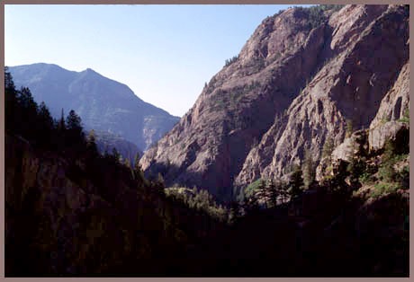
From South. (via Cement Creek road or Corkscrew Pass)
The three possible approaches to this pass are
difficult to divide into principal and alternate
approaches. Also, at least two interesting ways
exist to get to upper Cement Creek on the southern
approach. The most direct way is C110, heading
directly to Hurricane Pass from Silverton. Leaving
Silverton, a "dead end" sign advises travelers.
But a smaller sign a little later - too small to
be readable from most moving vehicles - also
points out of two passes in this direction, Corkscrew Pass and
Hurricane Pass. No mention is made of California Pass
yet, which is also accessible from here. That
comes one road transition later, after the route
has changed to a wide dirt road, passing by the
most rustic ski area in Colorado that I know. Soon
afterwards the road is face to face with major
mining operations in Gladstone. A sign naming all
three passes now points up a road to the left. The
road is quite steep, but smooth enough to be a
better climbing workout than 90 percent of
Colorado paved road passes. Slightly before
gaining half of the elevation required to reach
the summit, a steep track from Corkscrew Pass
descends from the left to join the Hurricane Pass
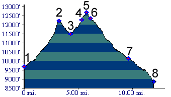
road. That's actually the route shown in the
profile above. But the description is on the Corkscrew Pass
page. A little higher some rocky spots demand that
everybody gets off the bike, but compared to other
unpaved roads used by motorized traffic, this is
really still a very smooth surface. If this part
of the approach is not rideable it is because of
sheer steepness, not because of loose rocks and
lack of traction.
From North. (via California Pass).
Approaching Hurricane Pass from the north requires
first crossing the higher California Pass. As
mentioned earlier, the short shelf road dip
between the two passes is a relatively new
phenomenon and not shown on most maps. (There s
more on the California
Pass page.) From West. (via Poughkeepsie Gulch) This
is the shortest route from pavement to the top of
Hurricane Pass. It is also the roughest, and
therefore far from the fastest. It is described in
a downward direction because traveling the
route this way is less torturous. The meandering
route heading down to Como Lake looks appealing
from the top of Hurricane Pass. After a short
decend to the low point between Hurricane Pass and
the next pass to the north, a sign advises that
travel along the downhill option is not advised.
But this sparks interest because it tends to keep
away motorized travelers. The problem with this
route is that for every 10 feet it descends, it
climbs 5, and all that over a majority of rocks.
Soon a route that appears like a narrow
manmade talus slope leads down to timberline. But
it doesn't get easier. Now the roadbed shares in
the water of the adjacent stream. Conditions
improve somewhat after the Poughkeepsie Gulch
joins the Engineer
Pass route. Finally, when you pass a shelf
cut into sheer rock with Red Mountain Pass
coming into view below, while traveling over a
rickety wooden bridge, it will probably all seem
to have been worthwhile. 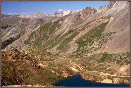
Dayrides.
History San Juan Mining Boom: (<Stony Pass) The pass is a demonstration for the remarkable talent of San Juan miners to locate ore near the top of mountain passes. Naturally at the time the pass was just a gap between mountains. The pass road itself is a result of the mines. Both Hurricane Pass and California Pass have mines located near the top, the Adelph and Alpha mine, the ruins of which can still be seen near the top today. According to "Passes of Colorado" the Cement Creek road approach of the pass was used between 1879 and the late 1880s to supply the two mines. This location puts them them right square in the middle between Ouray and Silverton. Both towns had railheads, which could be utilized to convert the ore into spendable money. After cycling, and also partially walking over the route, one may feel uniquely qualified to render an opinion on wich route is more practical. |
 Approaches
|
|
advertisement |
|
|
advertisement |